
Topografische Karte Ona
Interaktive Karte
Klicken Sie auf die Karte, um die Höhe anzuzeigen.
Über diese Karte
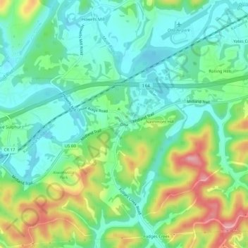
Name: Topografische Karte Ona, Höhe, Relief.
Ort: Ona, Cabell County, West Virginia, 25545, United States (38.40481 -82.23320 38.44481 -82.19320)
Durchschnittliche Höhe: 207 m
Minimale Höhe: 163 m
Maximale Höhe: 300 m
Andere topografische Karten
Klicken Sie auf eine Karte, um ihre Topografie, ihre Höhe und ihr Relief anzuzeigen.
Culloden
United States > West Virginia > Cabell County
Culloden, Cabell County, West Virginia, United States
Durchschnittliche Höhe: 238 m
Salt Rock
United States > West Virginia > Cabell County
Salt Rock, Cabell County, West Virginia, 25559, United States
Durchschnittliche Höhe: 226 m
Lesage
United States > West Virginia > Cabell County
Lesage, Cabell County, West Virginia, 25537, United States
Durchschnittliche Höhe: 210 m
Milton
United States > West Virginia > Cabell County
Milton, Cabell County, West Virginia, 25541, United States
Durchschnittliche Höhe: 216 m
Pea Ridge
United States > West Virginia > Cabell County > Barboursville > Tallwood Acres
Pea Ridge, Tallwood Acres, Barboursville, Cabell County, West Virginia, 25705, United States
Durchschnittliche Höhe: 197 m
Malcolm Springs Heights
United States > West Virginia > Cabell County
Malcolm Springs Heights, Cabell County, West Virginia, 25541, United States
Durchschnittliche Höhe: 211 m
Barboursville
United States > West Virginia > Cabell County
Barboursville, Cabell County, West Virginia, United States
Durchschnittliche Höhe: 212 m
Huntington
United States > West Virginia > Cabell County
Huntington, Cabell County, West Virginia, United States
Durchschnittliche Höhe: 218 m