
Topografische Karte Minnesota Valley State Recreation Area
Interaktive Karte
Klicken Sie auf die Karte, um die Höhe anzuzeigen.
Über diese Karte
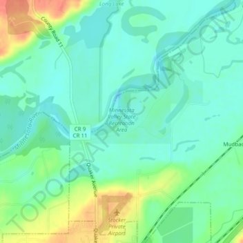
Name: Topografische Karte Minnesota Valley State Recreation Area, Höhe, Relief.
Durchschnittliche Höhe: 224 m
Minimale Höhe: 208 m
Maximale Höhe: 259 m
Andere topografische Karten
Klicken Sie auf eine Karte, um ihre Topografie, ihre Höhe und ihr Relief anzuzeigen.
Glendale
United States > Minnesota > Scott County > Savage
Glendale, Savage, Scott County, Minnesota, 55378, United States
Durchschnittliche Höhe: 262 m
Cedar Lake Township
United States > Minnesota > Scott County
Cedar Lake Township, Scott County, Minnesota, United States
Durchschnittliche Höhe: 300 m
Shakopee
United States > Minnesota > Scott County
Shakopee, Scott County, Minnesota, 55379, United States
Durchschnittliche Höhe: 257 m
Belle Plaine
United States > Minnesota > Scott County
Belle Plaine, Scott County, Minnesota, 56011, United States
Durchschnittliche Höhe: 258 m
Spring Lake Township
United States > Minnesota > Scott County
Spring Lake Township, Scott County, Minnesota, United States
Durchschnittliche Höhe: 293 m
Elko New Market
United States > Minnesota > Scott County
Elko New Market, Scott County, Minnesota, United States
Durchschnittliche Höhe: 340 m
Prior Lake
United States > Minnesota > Scott County
Prior Lake, Scott County, Minnesota, 55372, United States
Durchschnittliche Höhe: 282 m
Prior Lake
United States > Minnesota > Scott County > Prior Lake > Prior Lake
Prior Lake, Scott County, Minnesota, 55372, United States
Durchschnittliche Höhe: 289 m
The Wave
United States > Minnesota > Scott County > Shakopee
The Wave, Shakopee, Scott County, Minnesota, 55347, United States
Durchschnittliche Höhe: 222 m
Shakopee
United States > Minnesota > Scott County > Shakopee > Shakopee
Shakopee, Scott County, Minnesota, 55379, United States
Durchschnittliche Höhe: 248 m
Savage
United States > Minnesota > Scott County
Savage, Scott County, Minnesota, 55378, United States
Durchschnittliche Höhe: 262 m
Jordan
United States > Minnesota > Scott County
Jordan, Scott County, Minnesota, United States
Durchschnittliche Höhe: 260 m