
Topografische Karte Aegina
Interaktive Karte
Klicken Sie auf die Karte, um die Höhe anzuzeigen.
Über diese Karte
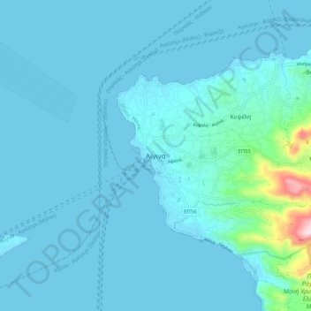
Name: Topografische Karte Aegina, Höhe, Relief.
Durchschnittliche Höhe: 27 m
Minimale Höhe: -2 m
Maximale Höhe: 365 m
Andere topografische Karten
Klicken Sie auf eine Karte, um ihre Topografie, ihre Höhe und ihr Relief anzuzeigen.
Methana
Greece > Attica > Regional Unit of Islands > Municipal Unit of Methana
Methana, Municipal Unit of Methana, Municipality of Troizinia - Methana, Regional Unit of Islands, Attica, 180 30, Greece
Durchschnittliche Höhe: 123 m
Lydia
Greece > Attica > Regional Unit of Islands
Lydia, Regional Unit of Islands, Attica, Greece
Durchschnittliche Höhe: 4 m
Ampelakia Municipal Unit
Greece > Attica > Regional Unit of Islands
Ampelakia Municipal Unit, Municipality of Salamina, Regional Unit of Islands, Attica, 189 02, Greece
Durchschnittliche Höhe: 55 m
Salamis
Greece > Attica > Regional Unit of Islands > Ampelakia Municipal Unit
Salamis, Ampelakia Municipal Unit, Municipality of Salamina, Regional Unit of Islands, Attica, Greece
Durchschnittliche Höhe: 38 m
Poros
Greece > Attica > Regional Unit of Islands > Poros
Poros, Municipality of Poros, Regional Unit of Islands, Attica, 180 20, Greece
Durchschnittliche Höhe: 31 m
Spetses
Greece > Attica > Regional Unit of Islands > Spetses
Spetses, Municipality of Spetses, Regional Unit of Islands, Attica, 180 50, Greece
Durchschnittliche Höhe: 33 m
Perani
Greece > Attica > Regional Unit of Islands > Salamina Municipal Unit
Perani, Salamina Municipal Unit, Municipality of Salamina, Regional Unit of Islands, Attica, 189 03, Greece
Durchschnittliche Höhe: 67 m
Aegina
Greece > Attica > Regional Unit of Islands > Kontos
Aegina, Kontos, Municipality of Aegina, Regional Unit of Islands, Attica, 180 10, Greece
Durchschnittliche Höhe: 60 m
Kythira
Greece > Attica > Regional Unit of Islands
Kythira, Regional Unit of Islands, Attica, Greece
Durchschnittliche Höhe: 75 m
Hydra
Greece > Attica > Regional Unit of Islands > Vlychos
Hydra, Vlychos, Municipality of Hydra, Regional Unit of Islands, Attica, 180 40, Greece
Durchschnittliche Höhe: 26 m