
Topografische Karte New Amsterdam Island
Interaktive Karte
Klicken Sie auf die Karte, um die Höhe anzuzeigen.
Über diese Karte
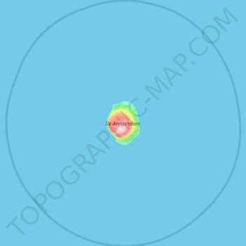
Name: Topografische Karte New Amsterdam Island, Höhe, Relief.
Durchschnittliche Höhe: 6 m
Minimale Höhe: 0 m
Maximale Höhe: 849 m
Andere topografische Karten
Klicken Sie auf eine Karte, um ihre Topografie, ihre Höhe und ihr Relief anzuzeigen.
Juan de Nova Island
France > French Southern and Antarctic Lands
Juan de Nova Island, Scattered Islands in the Indian Ocean, French Southern and Antarctic Lands, France
Durchschnittliche Höhe: 0 m
Port-aux-Français
France > French Southern and Antarctic Lands
Port-aux-Français, Kerguelen Archipelago, French Southern and Antarctic Lands, France
Durchschnittliche Höhe: 14 m
Mount Calliope
France > French Southern and Antarctic Lands
Mount Calliope, Kerguelen Archipelago, French Southern and Antarctic Lands, France
Durchschnittliche Höhe: 102 m
Possession Island
France > French Southern and Antarctic Lands
Possession Island, French Southern and Antarctic Lands, France
Durchschnittliche Höhe: 13 m
Mont de la Dives
France > French Southern and Antarctic Lands
Mont de la Dives, Saint Paul and New Amsterdam Islands, French Southern and Antarctic Lands, France
Durchschnittliche Höhe: 656 m
Kerguelen Archipelago
France > French Southern and Antarctic Lands
Kerguelen Archipelago, French Southern and Antarctic Lands, France
Durchschnittliche Höhe: 38 m
Penguin Island
France > French Southern and Antarctic Lands
Penguin Island, French Southern and Antarctic Lands, France
Durchschnittliche Höhe: 46 m