
Topografische Karte Locre
Interaktive Karte
Klicken Sie auf die Karte, um die Höhe anzuzeigen.
Über diese Karte
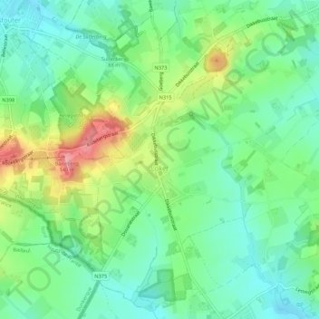
Name: Topografische Karte Locre, Höhe, Relief.
Ort: Locre, Heuvelland, Ypres, Flandre-Occidentale, 8958, Belgique (50.76792 2.75795 50.79918 2.81120)
Durchschnittliche Höhe: 73 m
Minimale Höhe: 37 m
Maximale Höhe: 143 m
Andere topografische Karten
Klicken Sie auf eine Karte, um ihre Topografie, ihre Höhe und ihr Relief anzuzeigen.
Dranoutre
Belgique > Flandre-Occidentale > Ypres > Heuvelland
Dranoutre, Heuvelland, Ypres, Flandre-Occidentale, 8951, Belgique
Durchschnittliche Höhe: 50 m
Wytschaete
Belgique > Flandre-Occidentale > Ypres > Heuvelland
Wytschaete, Heuvelland, Ypres, Flandre-Occidentale, Flandre, 8953, Belgique
Durchschnittliche Höhe: 42 m
Kemmel
Belgique > Flandre-Occidentale > Ypres > Heuvelland
Kemmel, Heuvelland, Ypres, Flandre-Occidentale, 8956, Belgique
Durchschnittliche Höhe: 49 m
Westoutre
Belgique > Flandre-Occidentale > Ypres > Heuvelland
Westoutre, Heuvelland, Ypres, Flandre-Occidentale, Belgique
Durchschnittliche Höhe: 59 m