
Topografische Karte South Oxfordshire
Interaktive Karte
Klicken Sie auf die Karte, um die Höhe anzuzeigen.
Über diese Karte
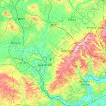
Name: Topografische Karte South Oxfordshire, Höhe, Relief.
Durchschnittliche Höhe: 97 m
Minimale Höhe: 28 m
Maximale Höhe: 261 m
Andere topografische Karten
Klicken Sie auf eine Karte, um ihre Topografie, ihre Höhe und ihr Relief anzuzeigen.
Didcot
United Kingdom > England > South Oxfordshire > Didcot
Didcot, South Oxfordshire, Oxfordshire, South East, England, OX11 8QZ, United Kingdom
Durchschnittliche Höhe: 68 m
Chinnor
United Kingdom > England > South Oxfordshire > Chinnor
Chinnor, South Oxfordshire, Oxfordshire, South East, England, OX39 4PZ, United Kingdom
Durchschnittliche Höhe: 133 m
Holton
United Kingdom > England > South Oxfordshire > Holton
Holton, South Oxfordshire, Oxfordshire, South East, England, United Kingdom
Durchschnittliche Höhe: 74 m