
Topografische Karte Nepean
Interaktive Karte
Klicken Sie auf die Karte, um die Höhe anzuzeigen.
Über diese Karte
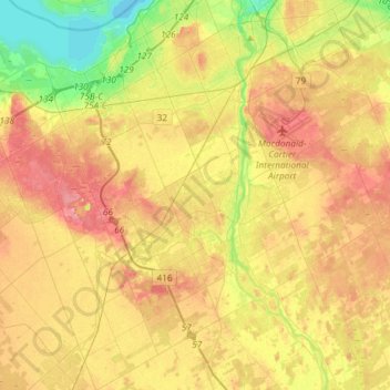
Name: Topografische Karte Nepean, Höhe, Relief.
Ort: Nepean, Ottawa, Eastern Ontario, Ontario, Canada (45.18039 -75.92008 45.38794 -75.68889)
Durchschnittliche Höhe: 93 m
Minimale Höhe: 51 m
Maximale Höhe: 130 m
Andere topografische Karten
Klicken Sie auf eine Karte, um ihre Topografie, ihre Höhe und ihr Relief anzuzeigen.
Gloucester
Gloucester, Ottawa, Eastern Ontario, Ontario, K0A 1K0, Canada, Bear Brook
Durchschnittliche Höhe: 77 m
Winding Way
Winding Way, Nepean, Ottawa, Eastern Ontario, Ontario, Canada
Durchschnittliche Höhe: 88 m
Orléans
Canada > Ontario > Ottawa > Cumberland
Orléans, Cumberland, Ottawa, Eastern Ontario, Ontario, Canada
Durchschnittliche Höhe: 66 m
Rideau Township
Canada > Ontario > Ottawa > Rideau Township
Rideau Township, Ottawa, Eastern Ontario, Ontario, Canada
Durchschnittliche Höhe: 102 m
West Carleton-March
Canada > Ontario > Ottawa > Constance Bay
West Carleton-March, Constance Bay, Ottawa, Ontario, K0A 3M0, Canada
Durchschnittliche Höhe: 69 m
Cumberland
Canada > Ontario > Ottawa > Cumberland
Cumberland, Sheenboro Crescent, Fallingbrook, Orléans, Cumberland, Ottawa, Eastern Ontario, Ontario, K4A 3S1, Canada
Durchschnittliche Höhe: 75 m
Cumberland
Canada > Ontario > Ottawa > Cumberland
Cumberland, Ottawa, Eastern Ontario, Ontario, Canada
Durchschnittliche Höhe: 75 m