
Topografische Karte Trémont
Interaktive Karte
Klicken Sie auf die Karte, um die Höhe anzuzeigen.
Über diese Karte
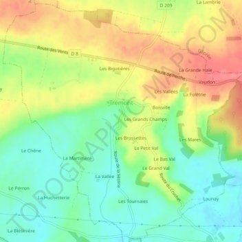
Name: Topografische Karte Trémont, Höhe, Relief.
Durchschnittliche Höhe: 203 m
Minimale Höhe: 171 m
Maximale Höhe: 241 m
Andere topografische Karten
Klicken Sie auf eine Karte, um ihre Topografie, ihre Höhe und ihr Relief anzuzeigen.
Neuvy-au-Houlme
Neuvy-au-Houlme, Argentan, Orne, Normandy, Metropolitan France, 61210, France
Durchschnittliche Höhe: 192 m
Domfront en Poiraie
Domfront en Poiraie, Argentan, Orne, Normandy, Metropolitan France, 61700, France
Durchschnittliche Höhe: 174 m
Vimoutiers
Vimoutiers, Mortagne-au-Perche, Orne, Normandy, Metropolitan France, 61120, France
Durchschnittliche Höhe: 172 m
Les Champeaux
Les Champeaux, Mortagne-au-Perche, Orne, Normandy, Metropolitan France, 61120, France
Durchschnittliche Höhe: 210 m
Chambois
France > Normandy > Orne > Gouffern en Auge
Chambois, Gouffern en Auge, Argentan, Orne, Normandy, Metropolitan France, 61160, France
Durchschnittliche Höhe: 115 m
Les Courtils
France > Normandy > Orne > Putanges-le-Lac > Putanges-Pont-Écrepin
Les Courtils, Putanges-Pont-Écrepin, Putanges-le-Lac, Argentan, Orne, Normandy, Metropolitan France, 61210, France
Durchschnittliche Höhe: 186 m
La Ferté-Macé
France > Normandy > Orne > La Ferté-Macé
La Ferté-Macé, Argentan, Orne, Normandy, Metropolitan France, 61600, France
Durchschnittliche Höhe: 216 m
La Rouge
France > Normandy > Orne > Val-au-Perche
La Rouge, Val-au-Perche, Mortagne-au-Perche, Orne, Normandy, Metropolitan France, 61260, France
Durchschnittliche Höhe: 127 m