
Topografische Karte Sreekrishnaswami Temple Pond,Thiruvampady
Interaktive Karte
Klicken Sie auf die Karte, um die Höhe anzuzeigen.
Über diese Karte
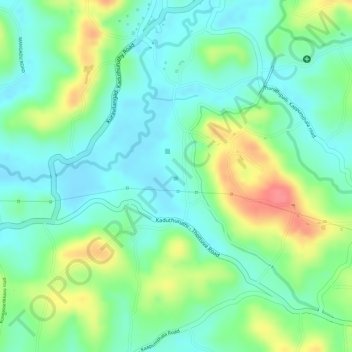
Name: Topografische Karte Sreekrishnaswami Temple Pond,Thiruvampady, Höhe, Relief.
Durchschnittliche Höhe: 30 m
Minimale Höhe: 3 m
Maximale Höhe: 77 m
Andere topografische Karten
Klicken Sie auf eine Karte, um ihre Topografie, ihre Höhe und ihr Relief anzuzeigen.
Muvatupuzha
India > Kerala > Vaikom > Velloor
Muvatupuzha, Velloor, Vaikom, Kottayam District, Kerala, India
Durchschnittliche Höhe: 14 m
Thalayolaparambu
Thalayolaparambu, Vaikom, Kottayam, Kerala, 686605, India
Durchschnittliche Höhe: 10 m
Vembanadu
India > Kerala > Vaikom > Kulangara Colony
Vembanadu, Laksham Veed Colony, Kulangara Colony, Vaikom, Kottayam, Kerala, India
Durchschnittliche Höhe: 2 m