
Topografische Karte 6th of October city
Interaktive Karte
Klicken Sie auf die Karte, um die Höhe anzuzeigen.
Über diese Karte
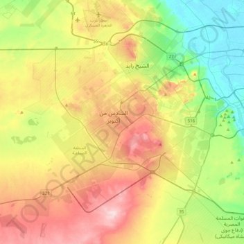
Name: Topografische Karte 6th of October city, Höhe, Relief.
Ort: 6th of October city, Giza, Egypt (29.83088 30.70266 30.09705 31.10069)
Durchschnittliche Höhe: 138 m
Minimale Höhe: 14 m
Maximale Höhe: 307 m
Andere topografische Karten
Klicken Sie auf eine Karte, um ihre Topografie, ihre Höhe und ihr Relief anzuzeigen.
Black Desert
Egypt > Giza > Northern Oases
Black Desert, Al Wahat Al Bahareya, Al Farafrah Road, Northern Oases, Giza, Egypt
Durchschnittliche Höhe: 188 m
Wadi Al-Hitan (Whale Valley)
Wadi Al-Hitan (Whale Valley), Giza, Egypt
Durchschnittliche Höhe: 123 m
Nazlet Al Siman and Al Sisi
Nazlet Al Siman and Al Sisi, Giza, Egypt
Durchschnittliche Höhe: 42 m
Smart Village
Egypt > Giza > Smart Village
Smart Village, Giza, 12577, Egypt
Durchschnittliche Höhe: 78 m
October Hills
Egypt > Giza > October Hills
October Hills, Giza, 12573, Egypt
Durchschnittliche Höhe: 158 m
Warraq al Hadar
Egypt > Giza > Warraq al Hadar
Warraq al Hadar, Giza, 12662, Egypt
Durchschnittliche Höhe: 21 m