
Spenden
Rüsten Sie sich für Ihr nächstes Abenteuer:
Als Amazon-Partner erhält diese Website eine Provision für qualifizierte Käufe, ohne zusätzliche Kosten für Sie.
Topografische Karte Borzont
Klicken Sie auf die Karte, um die Höhe anzuzeigen.
Spenden
Rüsten Sie sich für Ihr nächstes Abenteuer:
Als Amazon-Partner erhält diese Website eine Provision für qualifizierte Käufe, ohne zusätzliche Kosten für Sie.
Über diese Karte
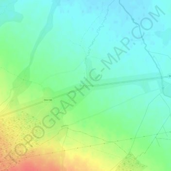
Name: Topografische Karte Borzont, Höhe, Relief.
Ort: Borzont, Joseni, Harghita, 537131, Romania (46.67538 25.42991 46.71538 25.46991)
Durchschnittliche Höhe: 745 m
Minimale Höhe: 728 m
Maximale Höhe: 779 m
Spenden
Rüsten Sie sich für Ihr nächstes Abenteuer:
Als Amazon-Partner erhält diese Website eine Provision für qualifizierte Käufe, ohne zusätzliche Kosten für Sie.
Andere topografische Karten
Klicken Sie auf eine Karte, um ihre Topografie, ihre Höhe und ihr Relief anzuzeigen.
Spenden
Rüsten Sie sich für Ihr nächstes Abenteuer:
Als Amazon-Partner erhält diese Website eine Provision für qualifizierte Käufe, ohne zusätzliche Kosten für Sie.
Spenden
Rüsten Sie sich für Ihr nächstes Abenteuer:
Als Amazon-Partner erhält diese Website eine Provision für qualifizierte Käufe, ohne zusätzliche Kosten für Sie.
Spenden
Rüsten Sie sich für Ihr nächstes Abenteuer:
Als Amazon-Partner erhält diese Website eine Provision für qualifizierte Käufe, ohne zusätzliche Kosten für Sie.
Băile Tușnad
With a population of 1,372 (as of 2021), it is the smallest town in Romania by population. It is located at an altitude of 650 m (2,130 ft) in the southern reaches of the Ciuc depression, between the Harghita and Bodoc mountains, in the valley of the Olt River, and is to this day an important spa town. The…
Durchschnittliche Höhe: 882 m
Spenden
Rüsten Sie sich für Ihr nächstes Abenteuer:
Als Amazon-Partner erhält diese Website eine Provision für qualifizierte Käufe, ohne zusätzliche Kosten für Sie.
Spenden
Rüsten Sie sich für Ihr nächstes Abenteuer:
Als Amazon-Partner erhält diese Website eine Provision für qualifizierte Käufe, ohne zusätzliche Kosten für Sie.
Spenden
Rüsten Sie sich für Ihr nächstes Abenteuer:
Als Amazon-Partner erhält diese Website eine Provision für qualifizierte Käufe, ohne zusätzliche Kosten für Sie.
Băile Tușnad
With a population of 1,617, it is the smallest town in Romania by population. It is located at an altitude of 650 metres in the southern reaches of the Ciuc depression, between the Harghita and Bodoc mountains, in the valley of the Olt, and is to this day an important spa town. The town administers one…
Durchschnittliche Höhe: 833 m
Borsec
Borsec, a resort chiefly known for its mineral water and favourable climate, is situated in the intracarpatic depression of the same name, at an altitude of 900 m (3,000 ft). The Borsec Depression has an oval shape and is northeast oriented, being separated from the hilltop of the Rotunda Chair in two…
Durchschnittliche Höhe: 1.053 m
Spenden
Rüsten Sie sich für Ihr nächstes Abenteuer:
Als Amazon-Partner erhält diese Website eine Provision für qualifizierte Käufe, ohne zusätzliche Kosten für Sie.