
Topografische Karte Great Basin National Park
Interaktive Karte
Klicken Sie auf die Karte, um die Höhe anzuzeigen.
Über diese Karte
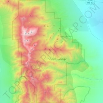
Name: Topografische Karte Great Basin National Park, Höhe, Relief.
Durchschnittliche Höhe: 2.352 m
Minimale Höhe: 1.566 m
Maximale Höhe: 3.938 m
The park derives its name from the Great Basin, the dry and mountainous region between the Sierra Nevada and the Wasatch Mountains. Topographically, this area is known as the Basin and Range Province. The park is located about 290 miles (470 km) north of Las Vegas and protects 77,180 acres (31,230 ha).
Andere topografische Karten
Klicken Sie auf eine Karte, um ihre Topografie, ihre Höhe und ihr Relief anzuzeigen.
Clock Spring
United States > Nevada > White Pine County
Clock Spring, Gleason Creek Road, White Pine County, Nevada, United States
Durchschnittliche Höhe: 2.522 m
Steptoe Valley
United States > Nevada > White Pine County
Steptoe Valley, White Pine County, Nevada, United States
Durchschnittliche Höhe: 2.142 m
McGill
United States > Nevada > White Pine County > McGill
McGill, White Pine County, Nevada, 89318, United States
Durchschnittliche Höhe: 1.973 m
Ely
United States > Nevada > White Pine County
Ely, White Pine County, Nevada, 89301, United States
Durchschnittliche Höhe: 2.045 m