
Topografische Karte Ambrosden
Interaktive Karte
Klicken Sie auf die Karte, um die Höhe anzuzeigen.
Über diese Karte
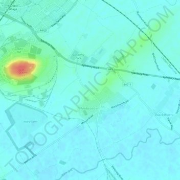
Name: Topografische Karte Ambrosden, Höhe, Relief.
Durchschnittliche Höhe: 66 m
Minimale Höhe: 58 m
Maximale Höhe: 114 m
Andere topografische Karten
Klicken Sie auf eine Karte, um ihre Topografie, ihre Höhe und ihr Relief anzuzeigen.
Cottisford
United Kingdom > England > Oxfordshire > Cherwell District
Cottisford, Cherwell District, Oxfordshire, England, United Kingdom
Durchschnittliche Höhe: 121 m
Launton
United Kingdom > England > Oxfordshire > Cherwell District
Launton, Cherwell District, Oxfordshire, England, United Kingdom
Durchschnittliche Höhe: 73 m
Kirtlington
United Kingdom > England > Oxfordshire > Cherwell District
Kirtlington, Cherwell District, Oxfordshire, England, United Kingdom
Durchschnittliche Höhe: 89 m
Deddington
United Kingdom > England > Oxfordshire > Cherwell District
Deddington, Cherwell District, Oxfordshire, England, United Kingdom
Durchschnittliche Höhe: 107 m
Bicester
United Kingdom > England > Oxfordshire > Cherwell District
Bicester, Cherwell District, Oxfordshire, England, United Kingdom
Durchschnittliche Höhe: 76 m
Adderbury
United Kingdom > England > Oxfordshire > Cherwell District
Adderbury, Cherwell District, Oxfordshire, England, United Kingdom
Durchschnittliche Höhe: 100 m
Banbury
United Kingdom > England > Oxfordshire > Cherwell District
Banbury, Cherwell District, Oxfordshire, England, United Kingdom
Durchschnittliche Höhe: 116 m