
Topografische Karte Pinewood
Interaktive Karte
Klicken Sie auf die Karte, um die Höhe anzuzeigen.
Über diese Karte
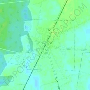
Name: Topografische Karte Pinewood, Höhe, Relief.
Ort: Pinewood, Sumter County, South Carolina, United States (33.73226 -80.47682 33.74749 -80.45271)
Durchschnittliche Höhe: 57 m
Minimale Höhe: 52 m
Maximale Höhe: 63 m
Andere topografische Karten
Klicken Sie auf eine Karte, um ihre Topografie, ihre Höhe und ihr Relief anzuzeigen.
Poinsett State Park
United States > South Carolina > Sumter County
Poinsett State Park, Sumter County, South Carolina, United States
Durchschnittliche Höhe: 54 m
Ranchland Ranchettes
United States > South Carolina > Sumter County
Ranchland Ranchettes, Sumter County, South Carolina, 29153, United States
Durchschnittliche Höhe: 45 m
South Sumter
United States > South Carolina > Sumter County > Shannontown
South Sumter, Shannontown, Sumter County, South Carolina, United States
Durchschnittliche Höhe: 43 m
Wedgewood
United States > South Carolina > Sumter County > Wedgefield > Wedgewood
Wedgewood, Wedgefield, Sumter County, South Carolina, United States
Durchschnittliche Höhe: 61 m
Dalzell
United States > South Carolina > Sumter County
Dalzell, Sumter County, South Carolina, 29040, United States
Durchschnittliche Höhe: 74 m
Wedgefield
United States > South Carolina > Sumter County
Wedgefield, Sumter County, South Carolina, 29168, United States
Durchschnittliche Höhe: 72 m
Rembert
United States > South Carolina > Sumter County
Rembert, Sumter County, South Carolina, United States
Durchschnittliche Höhe: 63 m