Geolokalisieren

Topografische Karte Montaione

Interaktive Karte

Klicken Sie auf die Karte, um die Höhe anzuzeigen.

Über diese Karte

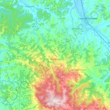
Name: Topografische Karte Montaione, Höhe, Relief.

Ort: Montaione, Unione dei comuni Circondario dell'Empolese Valdelsa, Florence, Tuscany, Italy (43.48724 10.82184 43.62935 10.94871)

Durchschnittliche Höhe: 186 m

Minimale Höhe: 43 m

Maximale Höhe: 553 m

Andere topografische Karten

Klicken Sie auf eine Karte, um ihre Topografie, ihre Höhe und ihr Relief anzuzeigen.

Greve

Italy > Tuscany > Florence

Greve, Florence, Tuscany, Italy

Durchschnittliche Höhe: 259 m

Scarperia

Italy > Tuscany > Florence

Scarperia, Scarperia e San Piero, Unione Montana dei Comuni del Mugello, Florence, Tuscany, Italy

Durchschnittliche Höhe: 275 m

Greve in Chianti

Italy > Tuscany > Florence

Greve in Chianti, Florence, Tuscany, Italy

Durchschnittliche Höhe: 364 m

Botinaccio

Italy > Tuscany > Florence > Montespertoli

Botinaccio, Montespertoli, Florence, Tuscany, 59015, Italy

Durchschnittliche Höhe: 156 m

Cintoia

Italy > Tuscany > Florence > Florence > Mantignano

Cintoia, Quartiere 4, Mantignano, Florence, Tuscany, 50145, Italy

Durchschnittliche Höhe: 41 m

Florence

Italy > Tuscany > Florence

Florence, Tuscany, Italy

Durchschnittliche Höhe: 142 m

Vinci

Italy > Tuscany > Florence

Vinci, Florence, Tuscany, Italy

Durchschnittliche Höhe: 122 m

Sant'Agostino

Italy > Tuscany > Florence > Gambassi Terme

Sant'Agostino, Gambassi Terme, Florence, Tuscany, Italy

Durchschnittliche Höhe: 246 m