
Topografische Karte Malton
Interaktive Karte
Klicken Sie auf die Karte, um die Höhe anzuzeigen.
Über diese Karte
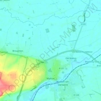
Name: Topografische Karte Malton, Höhe, Relief.
Ort: Malton, North Yorkshire, England, United Kingdom (54.12565 -0.82388 54.17406 -0.73200)
Durchschnittliche Höhe: 28 m
Minimale Höhe: 15 m
Maximale Höhe: 91 m
As with the rest of the British Isles and Yorkshire, Malton possesses a maritime climate with cool summers and mild winters. The nearest Met Office weather station for which records are available is High Mowthorpe, about 6 miles (10 km) east of the town centre. Due to its lower elevation, the town centre is likely to be marginally warmer than High Mowthorpe throughout the year.
Andere topografische Karten
Klicken Sie auf eine Karte, um ihre Topografie, ihre Höhe und ihr Relief anzuzeigen.
Scarborough
United Kingdom > England > North Yorkshire
Scarborough, North Yorkshire, England, YO11 1LP, United Kingdom
Durchschnittliche Höhe: 39 m
Longdales
United Kingdom > England > North Yorkshire
Longdales, Kettlewell with Starbotton, North Yorkshire, England, United Kingdom
Durchschnittliche Höhe: 436 m
Laverton
United Kingdom > England > North Yorkshire
Laverton, North Yorkshire, England, United Kingdom
Durchschnittliche Höhe: 172 m
Whitby
United Kingdom > England > North Yorkshire
Whitby, North Yorkshire, England, United Kingdom
Durchschnittliche Höhe: 37 m
Dalby
United Kingdom > England > North Yorkshire > Hambleton
Dalby, Dalby-cum-Skewsby, Hambleton, North Yorkshire, England, YO60 6PF, United Kingdom
Durchschnittliche Höhe: 80 m
Hunter Hill
United Kingdom > England > North Yorkshire > Craven District
Hunter Hill, Craven District, North Yorkshire, England, BD24 0JB, United Kingdom
Durchschnittliche Höhe: 312 m
East Rounton
United Kingdom > England > North Yorkshire > Hambleton
East Rounton, Hambleton, North Yorkshire, England, United Kingdom
Durchschnittliche Höhe: 65 m
Carlton in Cleveland
United Kingdom > England > North Yorkshire > Hambleton
Great Busby, Carlton in Cleveland, Hambleton, North Yorkshire, England, United Kingdom
Durchschnittliche Höhe: 112 m
Selby
United Kingdom > England > North Yorkshire > Selby
Selby, North Yorkshire, England, United Kingdom
Durchschnittliche Höhe: 7 m
Middleham
United Kingdom > England > North Yorkshire > Richmondshire > Middleham
Middleham, Richmondshire, North Yorkshire, Yorkshire and the Humber, England, United Kingdom
Durchschnittliche Höhe: 157 m
Cave Hill
United Kingdom > England > North Yorkshire > Craven
Cave Hill, Craven, North Yorkshire, Yorkshire and the Humber, England, BD24 0JQ, United Kingdom
Durchschnittliche Höhe: 351 m
Leyburn
United Kingdom > England > North Yorkshire > Richmondshire > Leyburn
Leyburn, Richmondshire, North Yorkshire, Yorkshire and the Humber, England, United Kingdom
Durchschnittliche Höhe: 195 m
Skipton
United Kingdom > England > North Yorkshire > Craven District
Skipton, Craven District, North Yorkshire, England, United Kingdom
Durchschnittliche Höhe: 173 m
Rylstone
United Kingdom > England > North Yorkshire > Craven > Rylstone
Rylstone, Craven, North Yorkshire, Yorkshire and the Humber, England, BD23 6LH, United Kingdom
Durchschnittliche Höhe: 236 m
River Derwent
United Kingdom > England > North Yorkshire
River Derwent, North Yorkshire, England, YO17 7DU, United Kingdom
Durchschnittliche Höhe: 56 m
Hill Top
United Kingdom > England > North Yorkshire
Hill Top, North Yorkshire, England, BD23 6PP, United Kingdom
Durchschnittliche Höhe: 231 m
Ouse
United Kingdom > England > North Yorkshire
Ouse, North Yorkshire, England, YO1 7DP, United Kingdom
Durchschnittliche Höhe: 18 m