
Spenden
Rüsten Sie sich für Ihr nächstes Abenteuer:
Als Amazon-Partner erhält diese Website eine Provision für qualifizierte Käufe, ohne zusätzliche Kosten für Sie.
Topografische Karte Praia Fluvial do Vidual de Cima
Klicken Sie auf die Karte, um die Höhe anzuzeigen.
Spenden
Rüsten Sie sich für Ihr nächstes Abenteuer:
Als Amazon-Partner erhält diese Website eine Provision für qualifizierte Käufe, ohne zusätzliche Kosten für Sie.
Über diese Karte
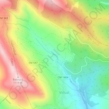
Name: Topografische Karte Praia Fluvial do Vidual de Cima, Höhe, Relief.
Durchschnittliche Höhe: 859 m
Minimale Höhe: 653 m
Maximale Höhe: 1.103 m
Spenden
Rüsten Sie sich für Ihr nächstes Abenteuer:
Als Amazon-Partner erhält diese Website eine Provision für qualifizierte Käufe, ohne zusätzliche Kosten für Sie.
Andere topografische Karten
Klicken Sie auf eine Karte, um ihre Topografie, ihre Höhe und ihr Relief anzuzeigen.
Portela de Unhais
Portugal > Coimbra > Pampilhosa da Serra > Unhais-o-Velho
Durchschnittliche Höhe: 726 m
Spenden
Rüsten Sie sich für Ihr nächstes Abenteuer:
Als Amazon-Partner erhält diese Website eine Provision für qualifizierte Käufe, ohne zusätzliche Kosten für Sie.
Spenden
Rüsten Sie sich für Ihr nächstes Abenteuer:
Als Amazon-Partner erhält diese Website eine Provision für qualifizierte Käufe, ohne zusätzliche Kosten für Sie.
Spenden
Rüsten Sie sich für Ihr nächstes Abenteuer:
Als Amazon-Partner erhält diese Website eine Provision für qualifizierte Käufe, ohne zusätzliche Kosten für Sie.
Spenden
Rüsten Sie sich für Ihr nächstes Abenteuer:
Als Amazon-Partner erhält diese Website eine Provision für qualifizierte Käufe, ohne zusätzliche Kosten für Sie.
Spenden
Rüsten Sie sich für Ihr nächstes Abenteuer:
Als Amazon-Partner erhält diese Website eine Provision für qualifizierte Käufe, ohne zusätzliche Kosten für Sie.