
Spenden
Rüsten Sie sich für Ihr nächstes Abenteuer:
Als Amazon-Partner erhält diese Website eine Provision für qualifizierte Käufe, ohne zusätzliche Kosten für Sie.
Topografische Karte Sirkazhi
Klicken Sie auf die Karte, um die Höhe anzuzeigen.
Spenden
Rüsten Sie sich für Ihr nächstes Abenteuer:
Als Amazon-Partner erhält diese Website eine Provision für qualifizierte Käufe, ohne zusätzliche Kosten für Sie.
Sirkazhi
Sirkazhi is located at 11°14′N 79°44′E / 11.23°N 79.73°E / 11.23; 79.73, on the eastern flank of the Kumbakonam-Shiyali ridge, which runs along the Kollidam River. Sirkazhi has an average elevation of 5.18 m (17.0 ft) above sea level and is located at 13 km (8.1 mi) west of Bay of Bengal. It is located 95 km (59 mi) north-east of Thanjavur, 24 km (15 mi) north of Mayiladuthurai and 20 kilometres (12 mi) south of Chidambaram.
Spenden
Rüsten Sie sich für Ihr nächstes Abenteuer:
Als Amazon-Partner erhält diese Website eine Provision für qualifizierte Käufe, ohne zusätzliche Kosten für Sie.
Über diese Karte
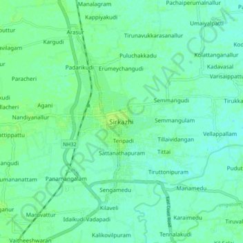
Name: Topografische Karte Sirkazhi, Höhe, Relief.
Durchschnittliche Höhe: 5 m
Minimale Höhe: 0 m
Maximale Höhe: 10 m
Spenden
Rüsten Sie sich für Ihr nächstes Abenteuer:
Als Amazon-Partner erhält diese Website eine Provision für qualifizierte Käufe, ohne zusätzliche Kosten für Sie.
Andere topografische Karten
Klicken Sie auf eine Karte, um ihre Topografie, ihre Höhe und ihr Relief anzuzeigen.
Cauvery
India > Tamil Nadu > Sirkali > Alangadu
The Kaveri (also known as Cauvery, the anglicised name) is one of the major Indian rivers flowing through the states of Karnataka and Tamil Nadu. The Kaveri River rises at Talakaveri in the Brahmagiri range in the Western Ghats, Kodagu district of the state of Karnataka, at an elevation of 1,341 m above mean…
Durchschnittliche Höhe: 7 m