
Topografische Karte Ponteland
Interaktive Karte
Klicken Sie auf die Karte, um die Höhe anzuzeigen.
Über diese Karte
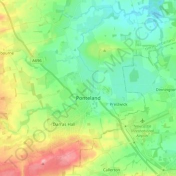
Name: Topografische Karte Ponteland, Höhe, Relief.
Durchschnittliche Höhe: 76 m
Minimale Höhe: 39 m
Maximale Höhe: 154 m
Andere topografische Karten
Klicken Sie auf eine Karte, um ihre Topografie, ihre Höhe und ihr Relief anzuzeigen.
Rothbury
United Kingdom > England > Northumberland
Rothbury, Northumberland, North of Tyne, England, United Kingdom
Durchschnittliche Höhe: 176 m
Chillingham
United Kingdom > England > Northumberland
Chillingham, Northumberland, North of Tyne, England, United Kingdom
Durchschnittliche Höhe: 115 m
Whiteadder Water
United Kingdom > England > Northumberland > Berwick-upon-Tweed > Newmills
Whiteadder Water, Newmills, Berwick-upon-Tweed, Northumberland, North of Tyne, England, United Kingdom
Durchschnittliche Höhe: 29 m
Dilston
United Kingdom > England > Northumberland > Corbridge
Dilston, Corbridge, Northumberland, North of Tyne, England, NE45 5RJ, United Kingdom
Durchschnittliche Höhe: 85 m
Warkworth
United Kingdom > England > Northumberland
Warkworth, Northumberland, North of Tyne, England, NE65 0UH, United Kingdom
Durchschnittliche Höhe: 20 m
Morpeth
United Kingdom > England > Northumberland
Morpeth, Northumberland, North of Tyne, England, United Kingdom
Durchschnittliche Höhe: 57 m
Berwick-upon-Tweed
United Kingdom > England > Northumberland
Berwick-upon-Tweed, Northumberland, North of Tyne, England, United Kingdom
Durchschnittliche Höhe: 33 m
Hexham
United Kingdom > England > Northumberland
Hexham, Northumberland, North of Tyne, England, United Kingdom
Durchschnittliche Höhe: 122 m
Horsley
United Kingdom > England > Northumberland
Horsley, Northumberland, North of Tyne, England, United Kingdom
Durchschnittliche Höhe: 93 m
Holy Island of Lindisfarne
United Kingdom > England > Northumberland > Holy Island
Holy Island of Lindisfarne, Holy Island, Northumberland, North East England, England, United Kingdom
Durchschnittliche Höhe: 1 m