
Topografische Karte Villacadima
Interaktive Karte
Klicken Sie auf die Karte, um die Höhe anzuzeigen.
Über diese Karte
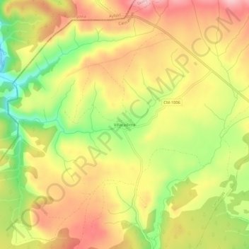
Name: Topografische Karte Villacadima, Höhe, Relief.
Durchschnittliche Höhe: 1.375 m
Minimale Höhe: 1.264 m
Maximale Höhe: 1.463 m
Andere topografische Karten
Klicken Sie auf eine Karte, um ihre Topografie, ihre Höhe und ihr Relief anzuzeigen.
Loma de Calamorro
España > Castilla-La Mancha > Cantalojas
Loma de Calamorro, Cantalojas, Guadalajara, Castilla-La Mancha, España
Durchschnittliche Höhe: 1.672 m
Parque Natural Hayedo Tejera Negra
España > Castilla-La Mancha > Cantalojas
Parque Natural Hayedo Tejera Negra, Senda del Robledal, Cantalojas, Guadalajara, Castilla-La Mancha, 19274, España
Durchschnittliche Höhe: 1.384 m