
Spenden
Rüsten Sie sich für Ihr nächstes Abenteuer:
Als Amazon-Partner erhält diese Website eine Provision für qualifizierte Käufe, ohne zusätzliche Kosten für Sie.
Topografische Karte Rivière des Prairies
Klicken Sie auf die Karte, um die Höhe anzuzeigen.
Spenden
Rüsten Sie sich für Ihr nächstes Abenteuer:
Als Amazon-Partner erhält diese Website eine Provision für qualifizierte Käufe, ohne zusätzliche Kosten für Sie.
Über diese Karte
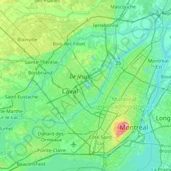
Name: Topografische Karte Rivière des Prairies, Höhe, Relief.
Durchschnittliche Höhe: 36 m
Minimale Höhe: -12 m
Maximale Höhe: 229 m
Spenden
Rüsten Sie sich für Ihr nächstes Abenteuer:
Als Amazon-Partner erhält diese Website eine Provision für qualifizierte Käufe, ohne zusätzliche Kosten für Sie.
Andere topografische Karten
Klicken Sie auf eine Karte, um ihre Topografie, ihre Höhe und ihr Relief anzuzeigen.
Mount Royal
Canada > Quebec > Urban agglomeration of Montreal > Montreal
The hill is part of the Monteregian Hills situated between the Laurentians and the Appalachian Mountains. It gave its Latin name, Mons Regius, to the Monteregian chain. The hill consists of three peaks: Colline de la Croix (or Mont Royal proper) at 233 m (764 ft), Colline d'Outremont (or Mount Murray, in the…
Durchschnittliche Höhe: 111 m
Parc Richelieu
Canada > Quebec > Urban agglomeration of Montreal > Montreal
Durchschnittliche Höhe: 15 m
Nuns' Island
Canada > Quebec > Urban agglomeration of Montreal > Montreal
Durchschnittliche Höhe: 13 m
Parc Léon-Provancher
Canada > Quebec > Urban agglomeration of Montreal > Montreal
Durchschnittliche Höhe: 53 m
Spenden
Rüsten Sie sich für Ihr nächstes Abenteuer:
Als Amazon-Partner erhält diese Website eine Provision für qualifizierte Käufe, ohne zusätzliche Kosten für Sie.
Saint Helen's Island
Canada > Quebec > Urban agglomeration of Montreal > Montreal
Durchschnittliche Höhe: 15 m
Mount Royal Park
Canada > Quebec > Urban agglomeration of Montreal > Montreal
The mountain is part of the Monteregian Hills situated between the Laurentians and the Appalachian Mountains. It gave its Latin name, Mons Regius, to the Monteregian chain. The mountain consists of three peaks: Colline de la Croix (or Mont Royal proper) at 233 m (764 ft), Colline d'Outremont (or Mount Murray,…
Durchschnittliche Höhe: 110 m
Cap Saint-Jacques
Canada > Quebec > Urban agglomeration of Montreal > Montreal
Durchschnittliche Höhe: 25 m
Mount Royal
Canada > Quebec > Urban agglomeration of Montreal > Montreal
The mountain is part of the Monteregian Hills situated between the Laurentians and the Appalachian Mountains. It gave its Latin name, Mons Regius, to the Monteregian chain. The mountain consists of three peaks: Colline de la Croix (or Mont Royal proper) at 233 m (764 ft), Colline d'Outremont (or Mount Murray,…
Durchschnittliche Höhe: 111 m
Spenden
Rüsten Sie sich für Ihr nächstes Abenteuer:
Als Amazon-Partner erhält diese Website eine Provision für qualifizierte Käufe, ohne zusätzliche Kosten für Sie.
Colline de l'Abri
Canada > Quebec > Urban agglomeration of Montreal > Montreal
Durchschnittliche Höhe: 120 m
Parc-nature du Bois-de-Liesse
Canada > Quebec > Urban agglomeration of Montreal > Montreal
Durchschnittliche Höhe: 28 m
Île aux Chats
Canada > Quebec > Urban agglomeration of Montreal > Montreal
Durchschnittliche Höhe: 25 m
Spenden
Rüsten Sie sich für Ihr nächstes Abenteuer:
Als Amazon-Partner erhält diese Website eine Provision für qualifizierte Käufe, ohne zusätzliche Kosten für Sie.
Victoria Square
Canada > Quebec > Urban agglomeration of Montreal > Montreal
Durchschnittliche Höhe: 31 m