
Topografische Karte Le Clos Bruneau
Interaktive Karte
Klicken Sie auf die Karte, um die Höhe anzuzeigen.
Über diese Karte
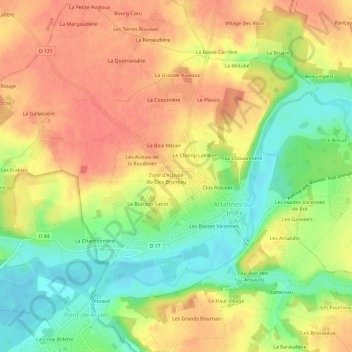
Name: Topografische Karte Le Clos Bruneau, Höhe, Relief.
Durchschnittliche Höhe: 74 m
Minimale Höhe: 41 m
Maximale Höhe: 99 m
Andere topografische Karten
Klicken Sie auf eine Karte, um ihre Topografie, ihre Höhe und ihr Relief anzuzeigen.
Le Buisson Sabot
France > Centre-Val de Loire > Indre-et-Loire > Artannes-sur-Indre
Le Buisson Sabot, Artannes-sur-Indre, Arrondissement de Tours, Indre-et-Loire, Centre-Val de Loire, France métropolitaine, 37260, France
Durchschnittliche Höhe: 72 m
Le Bourg
France > Centre-Val de Loire > Indre-et-Loire > Artannes-sur-Indre
Le Bourg, Artannes-sur-Indre, Tours, Indre-et-Loire, Centre-Val de Loire, France métropolitaine, 37260, France
Durchschnittliche Höhe: 73 m
Les Ansaults
France > Centre-Val de Loire > Indre-et-Loire > Artannes-sur-Indre
Les Ansaults, Artannes-sur-Indre, Tours, Indre-et-Loire, Centre-Val de Loire, France métropolitaine, 37260, France
Durchschnittliche Höhe: 73 m