
Topografische Karte Cairo
Interaktive Karte
Klicken Sie auf die Karte, um die Höhe anzuzeigen.
Über diese Karte
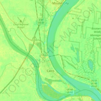
Name: Topografische Karte Cairo, Höhe, Relief.
Ort: Cairo, Alexander County, Illinois, 62914, United States (36.97030 -89.23146 37.08887 -89.13292)
Durchschnittliche Höhe: 95 m
Minimale Höhe: 85 m
Maximale Höhe: 107 m
Cairo (/ˈkɛəroʊ/ KAIR-oh, sometimes /ˈkeɪroʊ/ KAY-roh) is the southernmost city in Illinois and the county seat of Alexander County. A river city, Cairo has the lowest elevation of any location in Illinois and is the only Illinois city to be surrounded by levees. It is in the river-crossed area of Southern Illinois known as "Little Egypt", for which the city is named, after Egypt's capital on the Nile. The city is coterminous with Cairo Precinct.
Andere topografische Karten
Klicken Sie auf eine Karte, um ihre Topografie, ihre Höhe und ihr Relief anzuzeigen.
Cairo
United States > Illinois > Alexander County > Cairo > Cairo
Cairo, Alexander County, Illinois, 62914, United States
Durchschnittliche Höhe: 95 m
Dogtooth Bend Mounds
United States > Illinois > Alexander County
Dogtooth Bend Mounds, Alexander County, Illinois, 62962, United States
Durchschnittliche Höhe: 98 m
McClure
United States > Illinois > Alexander County
McClure, Alexander County, Illinois, United States
Durchschnittliche Höhe: 103 m
Big Cypress
United States > Illinois > Alexander County
Big Cypress, Alexander County, Illinois, 62969, United States
Durchschnittliche Höhe: 101 m
Thebes
United States > Illinois > Alexander County
Thebes, Alexander County, Illinois, 62990, United States
Durchschnittliche Höhe: 119 m