
Topografische Karte Wałbrzych
Interaktive Karte
Klicken Sie auf die Karte, um die Höhe anzuzeigen.
Über diese Karte
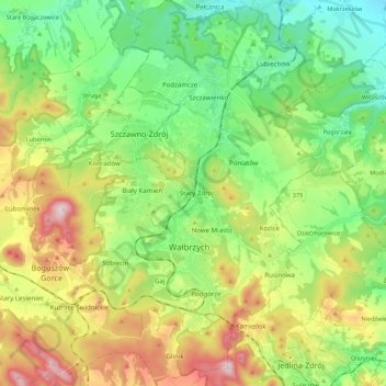
Name: Topografische Karte Wałbrzych, Höhe, Relief.
Durchschnittliche Höhe: 478 m
Minimale Höhe: 275 m
Maximale Höhe: 849 m
Wałbrzych is located in the of the Central Sudeten Mountains, near the border with the Czech Republic and Germany. The city is located by the Pełcznica River at 450-500 m above sea level in a picturesque structural basin of Wałbrzych above which there are wooded ranges of the Wałbrzych Mountains. The highest elevation in the city is Mount Borowa, also known as the Black Mountain, 853 m (2798ft) above sea level, with an observation tower since 2007, which is the highest peak of the Wałbrzych mountains.