
Topografische Karte Bon Accord Dam
Interaktive Karte
Klicken Sie auf die Karte, um die Höhe anzuzeigen.
Über diese Karte
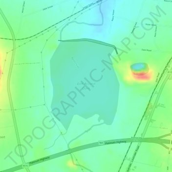
Name: Topografische Karte Bon Accord Dam, Höhe, Relief.
Durchschnittliche Höhe: 1.209 m
Minimale Höhe: 1.190 m
Maximale Höhe: 1.247 m
Andere topografische Karten
Klicken Sie auf eine Karte, um ihre Topografie, ihre Höhe und ihr Relief anzuzeigen.
Hennops river
South Africa > Gauteng > Pretoria
Hennops river, Pretoria, City of Tshwane Metropolitan Municipality, Gauteng, 0046, South Africa
Durchschnittliche Höhe: 1.436 m
Apies
South Africa > Gauteng > Pretoria
Apies, Pretoria, City of Tshwane Metropolitan Municipality, Gauteng, 0407, South Africa
Durchschnittliche Höhe: 1.110 m
Moreleta
South Africa > Gauteng > Pretoria
Moreleta, Pretoria, City of Tshwane Metropolitan Municipality, Gauteng, 0159, South Africa
Durchschnittliche Höhe: 1.270 m
Hennops
South Africa > Gauteng > Pretoria
Hennops, Pretoria, City of Tshwane Metropolitan Municipality, Gauteng, 0125, South Africa
Durchschnittliche Höhe: 1.381 m
Groenkloof Nature Reserve
South Africa > Gauteng > Pretoria
Groenkloof Nature Reserve, Royal Melbourne Close, Sterrewag, Tshwane Ward 59, Pretoria, City of Tshwane Metropolitan Municipality, Gauteng, 0105, South Africa
Durchschnittliche Höhe: 1.449 m
st albans pool
South Africa > Gauteng > Pretoria
st albans pool, Lynnwood Glen, Tshwane Ward 46, Pretoria, City of Tshwane Metropolitan Municipality, Gauteng, 0081, South Africa
Durchschnittliche Höhe: 1.380 m
Krokodil
South Africa > Gauteng > Pretoria
Krokodil, Pretoria, City of Tshwane Metropolitan Municipality, Gauteng, South Africa
Durchschnittliche Höhe: 1.222 m