
Topografische Karte Doues
Interaktive Karte
Klicken Sie auf die Karte, um die Höhe anzuzeigen.
Über diese Karte
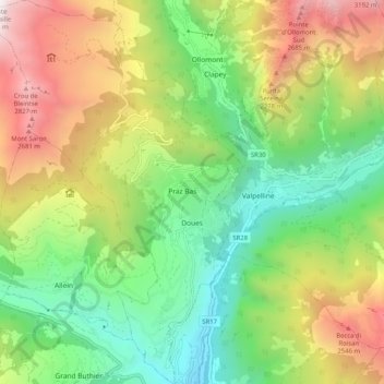
Name: Topografische Karte Doues, Höhe, Relief.
Ort: Doues, Aosta Valley, Italy (45.78958 7.25439 45.86060 7.31988)
Durchschnittliche Höhe: 1.661 m
Minimale Höhe: 757 m
Maximale Höhe: 3.073 m
Andere topografische Karten
Klicken Sie auf eine Karte, um ihre Topografie, ihre Höhe und ihr Relief anzuzeigen.
Clavon
Italy > Aosta Valley > Verrayes > Clavon
Clavon, Verrayes, Aosta Valley, Italy
Durchschnittliche Höhe: 1.574 m
La Thuile
Italy > Aosta Valley > La Thuile
La Thuile, Aosta Valley, Italy
Durchschnittliche Höhe: 2.257 m
Courmayeur
Italy > Aosta Valley > Courmayeur
Courmayeur, Aosta Valley, 11013, Italy
Durchschnittliche Höhe: 2.367 m
Valtournenche
Italy > Aosta Valley > Valtournenche
Valtournenche, Aosta Valley, Italy
Durchschnittliche Höhe: 2.640 m
Dent d'Hérens
Italy > Aosta Valley > Bionaz
Dent d'Hérens, Bionaz, Aosta Valley, Italy
Durchschnittliche Höhe: 3.354 m
Gran Paradiso
Italy > Aosta Valley > Valsavarenche
Gran Paradiso, Valsavarenche, Aosta Valley, Italy
Durchschnittliche Höhe: 3.459 m