
Topografische Karte Cobham
Interaktive Karte
Klicken Sie auf die Karte, um die Höhe anzuzeigen.
Cobham
The River Mole runs through Cobham, with a visitor area and well-surfaced path by the mill in the High Street, dividing the low-rise urban village/town centre from the remaining agricultural parts of Cobham in the west and south. This can flood small, old parts of the village centre in extreme rainfall. Elevation reaches a minimum here of 20 metres (66 ft) above sea level.
Über diese Karte
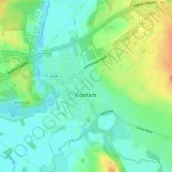
Name: Topografische Karte Cobham, Höhe, Relief.
Ort: Cobham, Elmbridge, Surrey, England, United Kingdom (51.32439 -0.42790 51.33843 -0.39933)
Durchschnittliche Höhe: 28 m
Minimale Höhe: 14 m
Maximale Höhe: 51 m