Geolokalisieren

Topografische Karte Stival

Interaktive Karte

Klicken Sie auf die Karte, um die Höhe anzuzeigen.

Über diese Karte

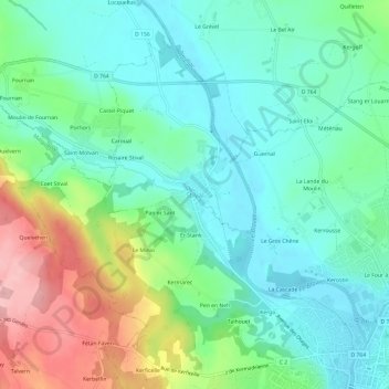
Name: Topografische Karte Stival, Höhe, Relief.

Ort: Stival, Pontivy, Morbihan, Bretagne, France métropolitaine, 56300, France (48.06534 -3.01304 48.10534 -2.97304)

Durchschnittliche Höhe: 102 m

Minimale Höhe: 54 m

Maximale Höhe: 215 m

Andere topografische Karten

Klicken Sie auf eine Karte, um ihre Topografie, ihre Höhe und ihr Relief anzuzeigen.

Le Gros Chêne

France > Bretagne > Morbihan > Pontivy > Stival

Le Gros Chêne, Stival, Pontivy, Morbihan, Bretagne, France métropolitaine, 56300, France

Durchschnittliche Höhe: 93 m

Le Four à Chaux

France > Bretagne > Morbihan > Pontivy

Le Four à Chaux, Pontivy, Morbihan, Bretagne, France métropolitaine, 56300, France

Durchschnittliche Höhe: 83 m

Kerostin

France > Bretagne > Morbihan > Pontivy > Sainte-Tréphine

Kerostin, Sainte-Tréphine, Pontivy, Morbihan, Bretagne, France métropolitaine, 56300, France

Durchschnittliche Höhe: 87 m