
Topografische Karte Baran
Klicken Sie auf die Karte, um die Höhe anzuzeigen.
Baran
Baran is located at 25°06′N 76°31′E / 25.1°N 76.52°E / 25.1; 76.52. It has an average elevation of 262 metres (859 ft). It is surrounded by three Rivers Kalisindh, Parvati and Parban. The city is situated on the border of Rajasthan and Madhya Pradesh.
Über diese Karte
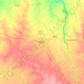
Name: Topografische Karte Baran, Höhe, Relief.
Ort: Baran, Baran Tehsil, Baran District, Rajasthan, 325205, India (24.93819 76.35699 25.25819 76.67699)
Durchschnittliche Höhe: 264 m
Minimale Höhe: 212 m
Maximale Höhe: 300 m