
Topografische Karte Ilam
Interaktive Karte
Klicken Sie auf die Karte, um die Höhe anzuzeigen.
Über diese Karte
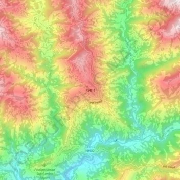
Name: Topografische Karte Ilam, Höhe, Relief.
Ort: Ilam, Illam, Ilam, Koshi Province, 57300, Nepal (26.87039 87.88819 26.95039 87.96819)
Durchschnittliche Höhe: 919 m
Minimale Höhe: 419 m
Maximale Höhe: 1.522 m
The word ‘Ilam’ comprises two words-‘I’ and ‘Lam’. In Limbu language, the word ‘I’ means ‘winding’ and ‘lam’ denotes the way. The topography of this Ilam aptly depicts several winding paths crisscrossing.
Andere topografische Karten
Klicken Sie auf eine Karte, um ihre Topografie, ihre Höhe und ihr Relief anzuzeigen.
Tumling
Nepal > Koshi Province > Ilam
Tumling, 03DR020, Sandakpur-05, Sandakpur, Ilam, Koshi Province, Nepal
Durchschnittliche Höhe: 2.759 m