
Topografische Karte Capalbio
Interaktive Karte
Klicken Sie auf die Karte, um die Höhe anzuzeigen.
Über diese Karte
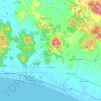
Name: Topografische Karte Capalbio, Höhe, Relief.
Ort: Capalbio, Grosseto, Tuscany, 58011, Italy (42.37773 11.30502 42.52907 11.54139)
Durchschnittliche Höhe: 76 m
Minimale Höhe: -5 m
Maximale Höhe: 421 m
Andere topografische Karten
Klicken Sie auf eine Karte, um ihre Topografie, ihre Höhe und ihr Relief anzuzeigen.
Le Viste
Italy > Tuscany > Grosseto > Porto Ercole > Borgo di Porto Ercole
Le Viste, Borgo di Porto Ercole, Porto Ercole, Monte Argentario, Grosseto, Tuscany, 58018, Italy
Durchschnittliche Höhe: 17 m
Case Fonte al Cerro
Italy > Tuscany > Grosseto > Puntone di Scarlino
Case Fonte al Cerro, Puntone di Scarlino, Scarlino, Grosseto, Tuscany, Italy
Durchschnittliche Höhe: 36 m
Santa Fiora
Santa Fiora, Unione dei Comuni Montani Amiata Grossetana, Grosseto, Tuscany, Italy
Durchschnittliche Höhe: 810 m
Santa Caterina
Santa Caterina, Roccalbegna, Unione dei Comuni Montani Amiata Grossetana, Grosseto, Tuscany, 58053, Italy
Durchschnittliche Höhe: 595 m
Giglio Porto
Italy > Tuscany > Grosseto > Giglio Porto
Giglio Porto, Isola del Giglio, Grosseto, Tuscany, 58013, Italy
Durchschnittliche Höhe: 106 m