
Topografische Karte Reno
Interaktive Karte
Klicken Sie auf die Karte, um die Höhe anzuzeigen.
Über diese Karte
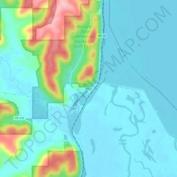
Name: Topografische Karte Reno, Höhe, Relief.
Ort: Reno, Houston County, Minnesota, United States (43.58108 -91.29513 43.62108 -91.25513)
Durchschnittliche Höhe: 223 m
Minimale Höhe: 188 m
Maximale Höhe: 352 m
Andere topografische Karten
Klicken Sie auf eine Karte, um ihre Topografie, ihre Höhe und ihr Relief anzuzeigen.
Eitzen
United States > Minnesota > Houston County
Eitzen, Houston County, Minnesota, United States
Durchschnittliche Höhe: 342 m
La Crescent
United States > Minnesota > Houston County
La Crescent, Houston County, Minnesota, 55947, United States
Durchschnittliche Höhe: 231 m
Willington Grove
United States > Minnesota > Houston County
Willington Grove, Houston County, Minnesota, United States
Durchschnittliche Höhe: 366 m
South Ridge
United States > Minnesota > Houston County
South Ridge, Houston County, Minnesota, United States
Durchschnittliche Höhe: 316 m
Wilmington
United States > Minnesota > Houston County
Wilmington, Houston County, Minnesota, United States
Durchschnittliche Höhe: 355 m
Caledonia
United States > Minnesota > Houston County
Caledonia, Houston County, Minnesota, 55921, United States
Durchschnittliche Höhe: 353 m
Bee
United States > Minnesota > Houston County
Bee, Houston County, Minnesota, United States
Durchschnittliche Höhe: 324 m
Money Creek
United States > Minnesota > Houston County
Money Creek, Houston County, Minnesota, United States
Durchschnittliche Höhe: 273 m
Pine Creek
United States > Minnesota > Houston County
Pine Creek, Houston County, Minnesota, United States
Durchschnittliche Höhe: 283 m
River Junction
United States > Minnesota > Houston County > La Crescent
River Junction, La Crescent, Houston County, Minnesota, 55947, United States
Durchschnittliche Höhe: 233 m
Hokah
United States > Minnesota > Houston County
Hokah, Houston County, Minnesota, United States
Durchschnittliche Höhe: 235 m
Newhouse
United States > Minnesota > Houston County
Newhouse, Houston County, Minnesota, 52131, United States
Durchschnittliche Höhe: 359 m
Perkins
United States > Minnesota > Houston County
Perkins, Houston County, Minnesota, United States
Durchschnittliche Höhe: 273 m
Schechs Mill
United States > Minnesota > Houston County > Sheldon
Schechs Mill, Sheldon, Houston County, Minnesota, United States
Durchschnittliche Höhe: 305 m
Riceford
United States > Minnesota > Houston County
Riceford, Houston County, Minnesota, United States
Durchschnittliche Höhe: 346 m
Sheldon
United States > Minnesota > Houston County
Sheldon, Houston County, Minnesota, United States
Durchschnittliche Höhe: 298 m
Yucatan
United States > Minnesota > Houston County
Yucatan, Houston County, Minnesota, United States
Durchschnittliche Höhe: 282 m
Brownsville
United States > Minnesota > Houston County
Brownsville, Houston County, Minnesota, United States
Durchschnittliche Höhe: 247 m
Spring Grove
United States > Minnesota > Houston County
Spring Grove, Houston County, Minnesota, 55974, United States
Durchschnittliche Höhe: 385 m