Geolokalisieren

Topografische Karte Champlain

Interaktive Karte

Klicken Sie auf die Karte, um die Höhe anzuzeigen.

Über diese Karte

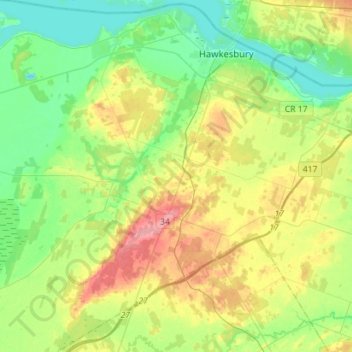
Name: Topografische Karte Champlain, Höhe, Relief.

Ort: Champlain, Prescott and Russell Counties, Eastern Ontario, Ontario, Canada (45.44243 -74.82360 45.64018 -74.56150)

Durchschnittliche Höhe: 68 m

Minimale Höhe: 35 m

Maximale Höhe: 128 m

Andere topografische Karten

Klicken Sie auf eine Karte, um ihre Topografie, ihre Höhe und ihr Relief anzuzeigen.

Rockland

Canada > Ontario > Prescott and Russell Counties

Rockland, Clarence-Rockland, Prescott and Russell Counties, Eastern Ontario, Ontario, K4K 1A0, Canada

Durchschnittliche Höhe: 59 m

Alfred and Plantagenet

Canada > Ontario > Prescott and Russell Counties

Alfred and Plantagenet, Prescott and Russell Counties, Eastern Ontario, Ontario, Canada

Durchschnittliche Höhe: 71 m

The Nation

Canada > Ontario > Prescott and Russell Counties

The Nation, Prescott and Russell Counties, Eastern Ontario, Ontario, Canada

Durchschnittliche Höhe: 72 m

Prescott and Russell Counties

Canada > Ontario > Prescott and Russell Counties

Prescott and Russell Counties, Eastern Ontario, Ontario, Canada

Durchschnittliche Höhe: 98 m