
Topografische Karte Pannecière
Interaktive Karte
Klicken Sie auf die Karte, um die Höhe anzuzeigen.
Über diese Karte
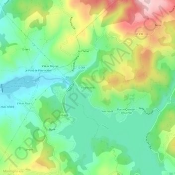
Name: Topografische Karte Pannecière, Höhe, Relief.
Durchschnittliche Höhe: 370 m
Minimale Höhe: 269 m
Maximale Höhe: 552 m
Andere topografische Karten
Klicken Sie auf eine Karte, um ihre Topografie, ihre Höhe und ihr Relief anzuzeigen.
Vauminot
France > Bourgogne-Franche-Comté > Nièvre > Chaumard
Vauminot, Chaumard, Château-Chinon (Ville), Nièvre, Bourgogne-Franche-Comté, France métropolitaine, 58120, France
Durchschnittliche Höhe: 366 m