
Topografische Karte Tso Moriri
Interaktive Karte
Klicken Sie auf die Karte, um die Höhe anzuzeigen.
Über diese Karte
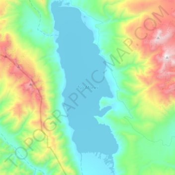
Name: Topografische Karte Tso Moriri, Höhe, Relief.
Ort: Tso Moriri, Leh District, Jammu and Kashmir, India (32.76360 78.25919 33.01494 78.37442)
Durchschnittliche Höhe: 5.044 m
Minimale Höhe: 4.516 m
Maximale Höhe: 6.657 m
Andere topografische Karten
Klicken Sie auf eine Karte, um ihre Topografie, ihre Höhe und ihr Relief anzuzeigen.
Kangan
Kangan, Ganderbal District, Jammu and Kashmir, India, The Blade
Durchschnittliche Höhe: 4.199 m
Shane
India > Jammu and Kashmir > Kishtwar
Shane, Kishtwar, Kishtwar District, Jammu and Kashmir, India
Durchschnittliche Höhe: 1.769 m
Kishtwar
Kishtwar, Kishtwar district, Jammu and Kashmir, India
Durchschnittliche Höhe: 2.605 m
Bhaderwah
India > Jammu and Kashmir > Bhaderwah
Bhaderwah, Doda District, Jammu and Kashmir, 182222, India
Durchschnittliche Höhe: 2.511 m
Rajouri
India > Jammu and Kashmir > Rajauri > Rajouri
Rajouri, Rajauri, Rajouri district, Jammu and Kashmir, 185131, India
Durchschnittliche Höhe: 1.038 m
Beerwah
India > Jammu and Kashmir > Beerwah
Beerwah, Budgam District, Jammu and Kashmir, India
Durchschnittliche Höhe: 1.785 m
Beerwah
India > Jammu and Kashmir > Beerwah tehsil
Beerwah, Beerwah tehsil, Budgam District, Jammu and Kashmir, 193411, India
Durchschnittliche Höhe: 1.803 m
Sonamarg
India > Jammu and Kashmir > Sonamarg
Sonamarg, Ganderbal, Jammu and Kashmir, India
Durchschnittliche Höhe: 3.354 m
Siachen Glacier
Siachen Glacier, Leh District, Ladakh, India
Durchschnittliche Höhe: 5.448 m
Central Chong Kumdan Glacier
Central Chong Kumdan Glacier, Leh District, Jammu and Kashmir, India
Durchschnittliche Höhe: 5.823 m
South Rimo Glacier
South Rimo Glacier, Leh District, Jammu and Kashmir, India
Durchschnittliche Höhe: 5.595 m
Nubra
India > Jammu and Kashmir > Leh
Nubra, Leh, Leh District, Jammu and Kashmir, India
Durchschnittliche Höhe: 3.205 m