
Topografische Karte East Champaran District
Interaktive Karte
Klicken Sie auf die Karte, um die Höhe anzuzeigen.
Über diese Karte
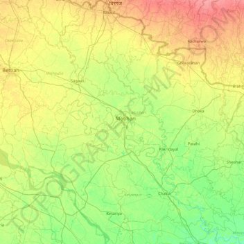
Name: Topografische Karte East Champaran District, Höhe, Relief.
Ort: East Champaran District, Bihar, India (26.25457 84.48528 27.02168 85.29697)
Durchschnittliche Höhe: 70 m
Minimale Höhe: 50 m
Maximale Höhe: 101 m
Raxaul is one of the most significant towns of the East Champaran district. By excellence of its topographical area, it is known as the Gateway to Nepal.
Andere topografische Karten
Klicken Sie auf eine Karte, um ihre Topografie, ihre Höhe und ihr Relief anzuzeigen.
Sonbhadra
India > Bihar > Sonbhadra Banshi Suryapur
Sonbhadra, Sonbhadra Banshi Suryapur, Arwal District, Bihar, 824120, India
Durchschnittliche Höhe: 74 m
West Champaran District
West Champaran District, Bihar, India
Durchschnittliche Höhe: 132 m
Samastipur
Samastipur, Samastipur District, Bihar, 848101, India
Durchschnittliche Höhe: 48 m
Kishanganj
Kishanganj, Madhepura District, Bihar, 852115, India
Durchschnittliche Höhe: 39 m
Pashchim Champāran
Pashchim Champāran, Pashchim Champaran, Bihar, India
Durchschnittliche Höhe: 207 m
Gehlour Ghati
Gehlour Ghati, Muhra, Gaya, Bihar, India
Durchschnittliche Höhe: 111 m
Sultanganj
India > Bihar > Sultanganj
Sultanganj, Bhagalpur, Bihar, 813223, India
Durchschnittliche Höhe: 38 m
Patna
India > Bihar > Patna Rural
Patna, Patna Rural, Patna District, Bihar, 800001, India
Durchschnittliche Höhe: 51 m