
Topografische Karte Belo Horizonte
Interaktive Karte
Klicken Sie auf die Karte, um die Höhe anzuzeigen.
Über diese Karte
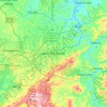
Name: Topografische Karte Belo Horizonte, Höhe, Relief.
Durchschnittliche Höhe: 904 m
Minimale Höhe: 675 m
Maximale Höhe: 1.508 m
In 1893, due to the climatic and topographic conditions, Curral Del Rey was selected by Minas Gerais governor Afonso Pena among other cities as the location for the new economic and cultural center of the state, under the new name of Cidade de Minas, or City of Minas.
Andere topografische Karten
Klicken Sie auf eine Karte, um ihre Topografie, ihre Höhe und ihr Relief anzuzeigen.
Estoril
Brazil > Minas Gerais > Região Metropolitana de Belo Horizonte > Belo Horizonte
Estoril, Regional Oeste, Belo Horizonte, Região Geográfica Imediata de Belo Horizonte, Região Metropolitana de Belo Horizonte, Região Geográfica Intermediária de Belo Horizonte, Minas Gerais, Southeast Region, Brazil
Durchschnittliche Höhe: 972 m