
Topografische Karte Waltham
Interaktive Karte
Klicken Sie auf die Karte, um die Höhe anzuzeigen.
Über diese Karte
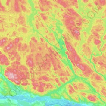
Name: Topografische Karte Waltham, Höhe, Relief.
Ort: Waltham, Pontiac (MRC), Outaouais, Quebec, J0X 3H0, Canada (45.89225 -77.04870 46.16432 -76.79797)
Durchschnittliche Höhe: 245 m
Minimale Höhe: 104 m
Maximale Höhe: 409 m
Its territory, with a maximum elevation of just over 350 metres (1,150 ft), is sparsely populated, the majority of the population living along or near the Ottawa River. The northern portion is a vast extended tract of undeveloped land, dotted with lakes, such as Findlay, Landon, Gagnon, and Caughlin, which are popular for fishing.