
Topografische Karte Rusava
Interaktive Karte
Klicken Sie auf die Karte, um die Höhe anzuzeigen.
Über diese Karte
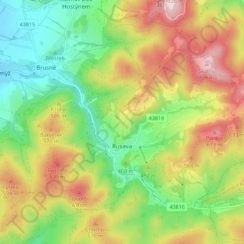
Name: Topografische Karte Rusava, Höhe, Relief.
Durchschnittliche Höhe: 482 m
Minimale Höhe: 301 m
Maximale Höhe: 722 m
Rusava is located in the Hostýn Hills. The highest point of the municipality is top of the Skalný mountain with an elevation of 709 metres (2,326 ft).