
Topografische Karte White Mountain
Interaktive Karte
Klicken Sie auf die Karte, um die Höhe anzuzeigen.
Über diese Karte
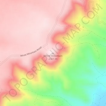
Name: Topografische Karte White Mountain, Höhe, Relief.
Ort: White Mountain, Sweetwater County, Wyoming, United States (41.57797 -109.32018 41.57807 -109.32008)
Durchschnittliche Höhe: 2.170 m
Minimale Höhe: 1.900 m
Maximale Höhe: 2.328 m
Andere topografische Karten
Klicken Sie auf eine Karte, um ihre Topografie, ihre Höhe und ihr Relief anzuzeigen.
Creston
United States > Wyoming > Sweetwater County
Creston, Sweetwater County, Wyoming, United States
Durchschnittliche Höhe: 2.162 m
North Rock Springs
United States > Wyoming > Sweetwater County
North Rock Springs, Sweetwater County, Wyoming, United States
Durchschnittliche Höhe: 2.083 m
Arrowhead Springs
United States > Wyoming > Sweetwater County > Arrowhead Springs
Arrowhead Springs, Sweetwater County, Wyoming, United States
Durchschnittliche Höhe: 2.056 m
Rock Springs
United States > Wyoming > Sweetwater County
Rock Springs, Sweetwater County, Wyoming, 82901, United States
Durchschnittliche Höhe: 2.024 m
Table Rock
United States > Wyoming > Sweetwater County
Table Rock, Sweetwater County, Wyoming, United States
Durchschnittliche Höhe: 2.110 m
Rock Springs
United States > Wyoming > Sweetwater County > Rock Springs
Rock Springs, Sweetwater County, Wyoming, 82901, United States
Durchschnittliche Höhe: 2.057 m
Point of Rocks
United States > Wyoming > Sweetwater County
Point of Rocks, Sweetwater County, Wyoming, United States
Durchschnittliche Höhe: 2.060 m
Green River
United States > Wyoming > Sweetwater County
Green River, Sweetwater County, Wyoming, 82935, United States
Durchschnittliche Höhe: 1.985 m