
Spenden
Rüsten Sie sich für Ihr nächstes Abenteuer:
Als Amazon-Partner erhält diese Website eine Provision für qualifizierte Käufe, ohne zusätzliche Kosten für Sie.
Topografische Karte Snowmass Village
Klicken Sie auf die Karte, um die Höhe anzuzeigen.
Spenden
Rüsten Sie sich für Ihr nächstes Abenteuer:
Als Amazon-Partner erhält diese Website eine Provision für qualifizierte Käufe, ohne zusätzliche Kosten für Sie.
Über diese Karte
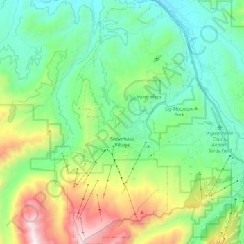
Name: Topografische Karte Snowmass Village, Höhe, Relief.
Durchschnittliche Höhe: 2.675 m
Minimale Höhe: 2.191 m
Maximale Höhe: 3.922 m
Spenden
Rüsten Sie sich für Ihr nächstes Abenteuer:
Als Amazon-Partner erhält diese Website eine Provision für qualifizierte Käufe, ohne zusätzliche Kosten für Sie.
Andere topografische Karten
Klicken Sie auf eine Karte, um ihre Topografie, ihre Höhe und ihr Relief anzuzeigen.
Castle Peak
United States > Colorado > Pitkin County
There are two other peaks in Colorado that have the same name: one in Eagle County at 39°46′23″N 106°50′04″W / 39.7730422°N 106.8344844°W / 39.7730422; -106.8344844, with an elevation 11,280+ feet, (3438+ m); and the other in Mesa County at 39°16′16″N 108°05′40″W /…
Durchschnittliche Höhe: 3.909 m
Spenden
Rüsten Sie sich für Ihr nächstes Abenteuer:
Als Amazon-Partner erhält diese Website eine Provision für qualifizierte Käufe, ohne zusätzliche Kosten für Sie.
Capitol Peak
United States > Colorado > Pitkin County
At the trail head, at an altitude of 9,400 feet, following several switchbacks for half a mile will lead you to Daly Pass. Daly Pass is the first point of interest on Capitol Peak. This pass is recognized for its saddle-shaped ridge reaching 12,480 feet.
Durchschnittliche Höhe: 3.750 m
Spenden
Rüsten Sie sich für Ihr nächstes Abenteuer:
Als Amazon-Partner erhält diese Website eine Provision für qualifizierte Käufe, ohne zusätzliche Kosten für Sie.
Maroon Bells
United States > Colorado > Pitkin County
Maroon Lake, elevation 2,920 m (9,580 ft), occupies a basin that was sculpted by Ice Age glaciers and later dammed by a landslide and rockfall debris from the steep slopes above the valley floor.
Durchschnittliche Höhe: 3.691 m
Spenden
Rüsten Sie sich für Ihr nächstes Abenteuer:
Als Amazon-Partner erhält diese Website eine Provision für qualifizierte Käufe, ohne zusätzliche Kosten für Sie.