
Topografische Karte Foster County
Interaktive Karte
Klicken Sie auf die Karte, um die Höhe anzuzeigen.
Über diese Karte
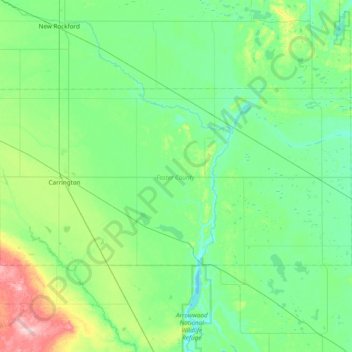
Name: Topografische Karte Foster County, Höhe, Relief.
Ort: Foster County, North Dakota, United States (47.32684 -99.26805 47.58875 -98.49907)
Durchschnittliche Höhe: 473 m
Minimale Höhe: 435 m
Maximale Höhe: 637 m
Andere topografische Karten
Klicken Sie auf eine Karte, um ihre Topografie, ihre Höhe und ihr Relief anzuzeigen.
Glenfield
United States > North Dakota > Foster County
Glenfield, Foster County, North Dakota, United States
Durchschnittliche Höhe: 457 m
Carrington
United States > North Dakota > Foster County
Carrington, Foster County, North Dakota, 58421, United States
Durchschnittliche Höhe: 484 m