Geolokalisieren

Topografische Karte Rio Tejo

Klicken Sie auf die Karte, um die Höhe anzuzeigen.

Über diese Karte
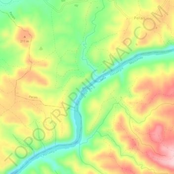
Name: Topografische Karte Rio Tejo, Höhe, Relief.

Ort: Rio Tejo, Perais, Vila Velha de Ródão, Nisa, Castelo Branco, Portugal (39.64312 -7.59707 39.66067 -7.54743)

Durchschnittliche Höhe: 160 m

Minimale Höhe: 61 m

Maximale Höhe: 264 m

Andere topografische Karten

Klicken Sie auf eine Karte, um ihre Topografie, ihre Höhe und ihr Relief anzuzeigen.
Vale do Cobrão

Portugal > Castelo Branco > Vila Velha de Ródão

Durchschnittliche Höhe: 322 m

Perais

Portugal > Castelo Branco > Vila Velha de Ródão

Durchschnittliche Höhe: 213 m

Penedo Gordo

Portugal > Castelo Branco > Vila Velha de Ródão

Durchschnittliche Höhe: 334 m

Montinho

Portugal > Castelo Branco > Vila Velha de Ródão

Durchschnittliche Höhe: 254 m

Alvaiade

Portugal > Castelo Branco > Vila Velha de Ródão

Durchschnittliche Höhe: 357 m

Foz do Cobrão

Portugal > Castelo Branco > Vila Velha de Ródão

Durchschnittliche Höhe: 257 m

Fratel

Portugal > Castelo Branco > Vila Velha de Ródão

Durchschnittliche Höhe: 223 m

Riscada

Portugal > Castelo Branco > Vila Velha de Ródão > Fratel

Durchschnittliche Höhe: 184 m

Perais

Portugal > Castelo Branco > Vila Velha de Ródão

Durchschnittliche Höhe: 213 m

Fratel

Portugal > Castelo Branco > Vila Velha de Ródão

Durchschnittliche Höhe: 223 m

Rüsten Sie sich für Ihr nächstes Abenteuer:

📦Dry Bags / Packsäcke - Hält Kleidung und Schlafsack im Rucksack trocken
👕Merino-Funktionswäsche - Natürliche Thermoregulation für jede Jahreszeit
🍲Camping-Kochsets - Platzsparendes Geschirr für die Outdoorküche
🩹Outdoor Pflaster Set - Wasserfeste Pflaster für unterwegs
🛠️Multitools - Der Werkzeugkasten für die Hosentasche

Als Amazon-Partner erhält diese Website eine Provision für qualifizierte Käufe, ohne zusätzliche Kosten für Sie.