
Topografische Karte Aylesford Lake
Interaktive Karte
Klicken Sie auf die Karte, um die Höhe anzuzeigen.
Über diese Karte
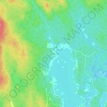
Name: Topografische Karte Aylesford Lake, Höhe, Relief.
Durchschnittliche Höhe: 224 m
Minimale Höhe: 199 m
Maximale Höhe: 280 m
Andere topografische Karten
Klicken Sie auf eine Karte, um ihre Topografie, ihre Höhe und ihr Relief anzuzeigen.
Aylesford Lake
Canada > Nova Scotia > Aylesford Lake
Aylesford Lake, Hilltop Lane, Aylesford Lake, Municipality of the County of Kings, Kings County, Nova Scotia, Canada
Durchschnittliche Höhe: 214 m