
Topografische Karte The West Lion
Interaktive Karte
Klicken Sie auf die Karte, um die Höhe anzuzeigen.
Über diese Karte
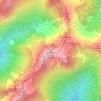
Name: Topografische Karte The West Lion, Höhe, Relief.
Ort: The West Lion, Electoral Area A, British Columbia, Canada (49.45780 -123.18627 49.45790 -123.18617)
Durchschnittliche Höhe: 1.159 m
Minimale Höhe: 724 m
Maximale Höhe: 1.585 m
Hikers can climb up to the ridge between the East and West Lion peaks using either the Binkert Trail leading up from Lions Bay, or the Howe Sound Crest Trail. The Binkert Trail, named after Paul Binkert of the British Columbia Mountaineering Club, is one of the most popular in the Lower Mainland. Hiking to the ridge from Lions Bay takes approximately four hours and gains 1,280 m (4,199 ft) in elevation. Most hikers stop there as both the East and West Lion peaks require rock climbing equipment and expertise. The East Lion is out-of-bounds for climbing as it is located in the Greater Vancouver watershed.
Andere topografische Karten
Klicken Sie auf eine Karte, um ihre Topografie, ihre Höhe und ihr Relief anzuzeigen.
North Shore Mountains
Canada > British Columbia > Electoral Area A
North Shore Mountains, Electoral Area A, Metro Vancouver Regional District, British Columbia, Canada
Durchschnittliche Höhe: 634 m
Tangled Summit
Canada > British Columbia > Electoral Area A
Tangled Summit, Electoral Area A, Metro Vancouver Regional District, British Columbia, Canada
Durchschnittliche Höhe: 851 m