
Spenden
Rüsten Sie sich für Ihr nächstes Abenteuer:
Als Amazon-Partner erhält diese Website eine Provision für qualifizierte Käufe, ohne zusätzliche Kosten für Sie.
Topografische Karte Copalnic
Klicken Sie auf die Karte, um die Höhe anzuzeigen.
Spenden
Rüsten Sie sich für Ihr nächstes Abenteuer:
Als Amazon-Partner erhält diese Website eine Provision für qualifizierte Käufe, ohne zusätzliche Kosten für Sie.
Über diese Karte
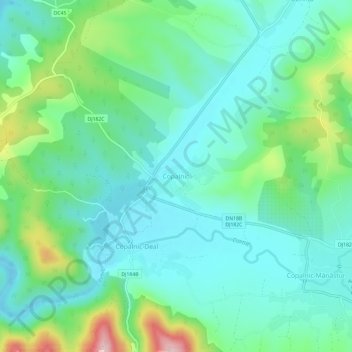
Name: Topografische Karte Copalnic, Höhe, Relief.
Ort: Copalnic, Copalnic-Mănăștur, Maramureș, 437103, Romania (47.50042 23.63563 47.54042 23.67563)
Durchschnittliche Höhe: 290 m
Minimale Höhe: 223 m
Maximale Höhe: 498 m
Spenden
Rüsten Sie sich für Ihr nächstes Abenteuer:
Als Amazon-Partner erhält diese Website eine Provision für qualifizierte Käufe, ohne zusätzliche Kosten für Sie.
Andere topografische Karten
Klicken Sie auf eine Karte, um ihre Topografie, ihre Höhe und ihr Relief anzuzeigen.
Spenden
Rüsten Sie sich für Ihr nächstes Abenteuer:
Als Amazon-Partner erhält diese Website eine Provision für qualifizierte Käufe, ohne zusätzliche Kosten für Sie.
Baia Mare
The city is situated in the vicinity of the Gutâi and Igniș mountains. Altitudes reach 1,400 metres (4,600 feet) in some peaks. The area is famous for its outstanding landscapes, and the mountains are easily accessible from the city, notable routes being: Igniș (1,307 m), Mogoșa (1,246 m), Gutâi (1,443…
Durchschnittliche Höhe: 592 m
Spenden
Rüsten Sie sich für Ihr nächstes Abenteuer:
Als Amazon-Partner erhält diese Website eine Provision für qualifizierte Käufe, ohne zusätzliche Kosten für Sie.
Spenden
Rüsten Sie sich für Ihr nächstes Abenteuer:
Als Amazon-Partner erhält diese Website eine Provision für qualifizierte Käufe, ohne zusätzliche Kosten für Sie.
Spenden
Rüsten Sie sich für Ihr nächstes Abenteuer:
Als Amazon-Partner erhält diese Website eine Provision für qualifizierte Käufe, ohne zusätzliche Kosten für Sie.
Baia Mare
The city is situated in the vicinity of the Gutâi and Igniș Mountains. Altitudes reach 1400 meters in some peaks. The area is famous for its outstanding landscapes, and the mountains are easily accessible from the city, famous routes being: Igniș (1307 m), Mogoșa (1246 m), Gutâi (1443 m), Creasta…
Durchschnittliche Höhe: 592 m
Spenden
Rüsten Sie sich für Ihr nächstes Abenteuer:
Als Amazon-Partner erhält diese Website eine Provision für qualifizierte Käufe, ohne zusätzliche Kosten für Sie.
Spenden
Rüsten Sie sich für Ihr nächstes Abenteuer:
Als Amazon-Partner erhält diese Website eine Provision für qualifizierte Käufe, ohne zusätzliche Kosten für Sie.
Spenden
Rüsten Sie sich für Ihr nächstes Abenteuer:
Als Amazon-Partner erhält diese Website eine Provision für qualifizierte Käufe, ohne zusätzliche Kosten für Sie.
Vișeu de Sus
Vișeu de Sus is located in the northeastern part of Maramureș County, on the border with Ukraine. The town lies at the confluence of the rivers Vișeu and Vaser, at an altitude of 427 m (1,401 ft) above sea level, having the characteristics of a mountain city. It neighbors the communes of Moisei to the…
Durchschnittliche Höhe: 865 m