
Topografische Karte Santiago de Chuco
Interaktive Karte
Klicken Sie auf die Karte, um die Höhe anzuzeigen.
Über diese Karte
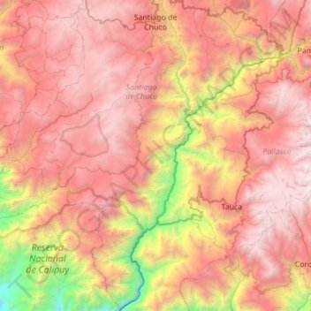
Name: Topografische Karte Santiago de Chuco, Höhe, Relief.
Durchschnittliche Höhe: 2.959 m
Minimale Höhe: 574 m
Maximale Höhe: 4.850 m
Andere topografische Karten
Klicken Sie auf eine Karte, um ihre Topografie, ihre Höhe und ihr Relief anzuzeigen.
Province of Ascope
Province of Ascope, La Libertad, Peru
Durchschnittliche Höhe: 1.046 m
Chepen
Peru > La Libertad > Salpo
Chepen, Salpo, Province of Otuzco, La Libertad, Peru
Durchschnittliche Höhe: 3.481 m
Yaman
Peru > La Libertad > Chugay
Yaman, Chugay, Province of Sánchez Carrión, La Libertad, Peru
Durchschnittliche Höhe: 2.752 m
Asia
Peru > La Libertad > Buldibuyo
Asia, Buldibuyo, Province of Pataz, La Libertad, Peru
Durchschnittliche Höhe: 3.078 m
Huanchaquito
Peru > La Libertad > Huanchaco
Huanchaquito, Huanchaco, Province of Trujillo, La Libertad, 13000, Peru
Durchschnittliche Höhe: 12 m
El Porvenir
Peru > La Libertad > El Porvenir
El Porvenir, Province of Trujillo, La Libertad, Peru
Durchschnittliche Höhe: 236 m
Laredo
Peru > La Libertad > Laredo
Laredo, Province of Trujillo, La Libertad, Peru
Durchschnittliche Höhe: 423 m
Trujillo
Trujillo, Province of Trujillo, La Libertad, Peru
Durchschnittliche Höhe: 37 m
El Inca
Peru > La Libertad > Chao > El Inca
El Inca, Chao, Province of Virú, La Libertad, Peru
Durchschnittliche Höhe: 132 m
Province of Chepén
Province of Chepén, La Libertad, Peru
Durchschnittliche Höhe: 222 m
Province of Pataz
Province of Pataz, La Libertad, 041, Peru
Durchschnittliche Höhe: 2.998 m
La Esperanza
La Esperanza, Province of Trujillo, La Libertad, Peru
Durchschnittliche Höhe: 115 m
Province of Santiago de Chuco
Peru > La Libertad > Santa Cruz de Chuca
Province of Santiago de Chuco, Santa Cruz de Chuca, Santiago de Chuco, La Libertad, Peru
Durchschnittliche Höhe: 3.294 m
San José de Moro
Peru > La Libertad > San José de Moro
San José de Moro, Province of Chepén, La Libertad, Peru
Durchschnittliche Höhe: 117 m