
Topografische Karte Balls Head
Interaktive Karte
Klicken Sie auf die Karte, um die Höhe anzuzeigen.
Über diese Karte
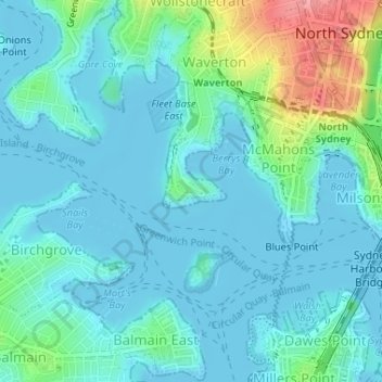
Name: Topografische Karte Balls Head, Höhe, Relief.
Durchschnittliche Höhe: 19 m
Minimale Höhe: -2 m
Maximale Höhe: 99 m
Andere topografische Karten
Klicken Sie auf eine Karte, um ihre Topografie, ihre Höhe und ihr Relief anzuzeigen.
Sydney International Regatta Centre
Australia > New South Wales > Sydney > Penrith
Sydney International Regatta Centre, Castlereagh, Penrith, Sydney, Penrith City Council, New South Wales, 2749, Australia
Durchschnittliche Höhe: 19 m
Narellan
Australia > New South Wales > Sydney
Narellan, Sydney, Camden Council, New South Wales, 2567, Australia
Durchschnittliche Höhe: 88 m
St Ives
Australia > New South Wales > Sydney
St Ives, Sydney, Ku-ring-gai Council, Upper North Shore, New South Wales, 2075, Australia
Durchschnittliche Höhe: 125 m
Waterloo
Australia > New South Wales > Sydney
Waterloo, Sydney, Council of the City of Sydney, New South Wales, 2017, Australia
Durchschnittliche Höhe: 29 m
Waterfall
Australia > New South Wales > Sydney
Waterfall, Sydney, Sutherland Shire Council, New South Wales, 2233, Australia
Durchschnittliche Höhe: 178 m
Shelly Beach
Australia > New South Wales > Sydney
Shelly Beach, Cronulla, Sydney, Sutherland Shire Council, Sutherland Shire, New South Wales, 2230, Australia
Durchschnittliche Höhe: 6 m
Tregear
Australia > New South Wales > Sydney
Tregear, Sydney, Blacktown City Council, New South Wales, 2770, Australia
Durchschnittliche Höhe: 40 m