Geolokalisieren

Topografische Karte Olancha

Klicken Sie auf die Karte, um die Höhe anzuzeigen.

👉 Easily get elevation data in JSON, GeoTIFF and KML formats using Elevation API
Vielen Dank für die Unterstützung dieser Website ❤️
Spenden

Rüsten Sie sich für Ihr nächstes Abenteuer:

Als Amazon-Partner erhält diese Website eine Provision für qualifizierte Käufe, ohne zusätzliche Kosten für Sie.

Olancha

Olancha (Timbisha: Pakwa' si) is a census designated place in Inyo County of the U.S. state of California. Olancha is located on U.S. Route 395 in California, 37 miles (60 km) south-southeast of Independence, at an elevation of 3658 feet (1115 m). As of the 2010 census, the population was 192, up from 134 at the 2000 census.

Wikipedia (CC-BY-SA 3.0)

Über diese Karte

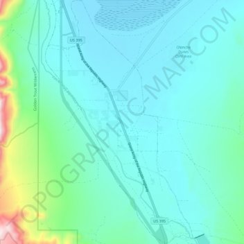
Name: Topografische Karte Olancha, Höhe, Relief.

Ort: Olancha, Inyo County, California, 93549, United States (36.22640 -118.03488 36.31523 -117.96833)

Durchschnittliche Höhe: 1.200 m

Minimale Höhe: 1.092 m

Maximale Höhe: 1.789 m

Andere topografische Karten

Klicken Sie auf eine Karte, um ihre Topografie, ihre Höhe und ihr Relief anzuzeigen.

Independence

United States > California > Inyo County

Independence is a census-designated place in Inyo County, California. Independence is located 41 miles (66 km) south-southeast of Bishop, at an elevation of 3930 feet (1198 m). It is the county seat of Inyo County, California. The population of this census-designated place was 669 at the 2010 census, up from…

Durchschnittliche Höhe: 1.210 m

Round Valley

United States > California > Inyo County

Round Valley is a census-designated place (CDP) in Inyo County, California, United States. Round Valley is located 7.5 miles (12 km) northeast of Mount Tom, at an elevation of 4692 feet (1430 m). The population was 435 at the 2010 census, up from 278 at the 2000 census.

Durchschnittliche Höhe: 1.491 m

Fish Springs

United States > California > Inyo County

Durchschnittliche Höhe: 1.239 m

Ryan

United States > California > Inyo County

Durchschnittliche Höhe: 967 m

Vielen Dank für die Unterstützung dieser Website ❤️
Spenden

Rüsten Sie sich für Ihr nächstes Abenteuer:

Als Amazon-Partner erhält diese Website eine Provision für qualifizierte Käufe, ohne zusätzliche Kosten für Sie.

Chicago Valley

United States > California > Inyo County

Durchschnittliche Höhe: 661 m

Swansea

United States > California > Inyo County

Durchschnittliche Höhe: 1.198 m

Reward

United States > California > Inyo County

Durchschnittliche Höhe: 1.364 m

Beveridge

United States > California > Inyo County

Durchschnittliche Höhe: 2.073 m

Park Village

United States > California > Inyo County

Durchschnittliche Höhe: 64 m

Harrisburg

United States > California > Inyo County

Durchschnittliche Höhe: 1.595 m

Owenyo

United States > California > Inyo County

Durchschnittliche Höhe: 1.171 m

Mock

United States > California > Inyo County

Durchschnittliche Höhe: 1.172 m

Deep Springs

United States > California > Inyo County

Durchschnittliche Höhe: 1.630 m

Death Valley Junction

United States > California > Inyo County

Durchschnittliche Höhe: 627 m

Cirque Peak

United States > California > Inyo County

Durchschnittliche Höhe: 3.600 m

Shadow Mountain

United States > California > Inyo County

Durchschnittliche Höhe: 1.230 m

Furnace Creek

United States > California > Inyo County

Durchschnittliche Höhe: -27 m

Ballarat

United States > California > Inyo County

Durchschnittliche Höhe: 363 m

Owens Valley

United States > California > Inyo County

Durchschnittliche Höhe: 2.090 m

Little Lake

United States > California > Inyo County

Durchschnittliche Höhe: 1.086 m

Vielen Dank für die Unterstützung dieser Website ❤️
Spenden

Rüsten Sie sich für Ihr nächstes Abenteuer:

Als Amazon-Partner erhält diese Website eine Provision für qualifizierte Käufe, ohne zusätzliche Kosten für Sie.

Mount LeConte

United States > California > Inyo County

Durchschnittliche Höhe: 3.789 m

Mount Perry

United States > California > Inyo County

Durchschnittliche Höhe: 1.321 m

Upper Lamarck Lake

United States > California > Inyo County

Durchschnittliche Höhe: 3.457 m

Kearsarge

United States > California > Inyo County

Durchschnittliche Höhe: 1.159 m

Vielen Dank für die Unterstützung dieser Website ❤️
Spenden

Rüsten Sie sich für Ihr nächstes Abenteuer:

Als Amazon-Partner erhält diese Website eine Provision für qualifizierte Käufe, ohne zusätzliche Kosten für Sie.

Gem Lakes

United States > California > Inyo County

Durchschnittliche Höhe: 3.481 m

Big Pine

United States > California > Inyo County

Big Pine (formerly Bigpine) is a census-designated place (CDP) in Inyo County, California, United States. Big Pine is located approximately 15 miles (24 km) south-southeast of Bishop, at an elevation of 3,989 feet (1,216 m). The population was 1,756 at the 2010 census, up from 1,350 at the 2000 census. The Big…

Durchschnittliche Höhe: 1.232 m

Charleston View

United States > California > Inyo County

Charleston View, formally known as Calvada Springs, is an unincorporated community in Inyo County, California. It lies at an elevation of 2621 feet (799 m). The Charleston View CDP had a population of 45 in the 2020 census

Durchschnittliche Höhe: 802 m

Pearsonville

United States > California > Inyo County

Durchschnittliche Höhe: 796 m

Shoshone

United States > California > Inyo County

Durchschnittliche Höhe: 518 m

Tecopa

United States > California > Inyo County

Durchschnittliche Höhe: 438 m

Dante's View

United States > California > Inyo County

Durchschnittliche Höhe: 1.403 m

Darwin Falls

United States > California > Inyo County

Durchschnittliche Höhe: 988 m

Alabama Hills

United States > California > Inyo County

Alabama Hills is an unincorporated community in the Alabama Hills, in Inyo County, California.[1] It lies at an elevation of 4534 feet (1382 m).[1] The community was named after the CSS Alabama.[2]

Durchschnittliche Höhe: 1.427 m

Wildrose Peak

United States > California > Inyo County

Durchschnittliche Höhe: 2.402 m

China Ranch

United States > California > Inyo County > China Ranch

Durchschnittliche Höhe: 446 m

Pinon Peak

United States > California > Inyo County

Durchschnittliche Höhe: 2.143 m

Dirty Socks Hot Spring

United States > California > Inyo County > Olancha

Durchschnittliche Höhe: 1.105 m

Mount Haeckel

United States > California > Inyo County

Durchschnittliche Höhe: 3.726 m

Towne Benchmark

United States > California > Inyo County

Durchschnittliche Höhe: 1.933 m

Big Pine Creek

United States > California > Inyo County > Big Pine

Durchschnittliche Höhe: 1.210 m

Palisade Glacier

United States > California > Inyo County

Durchschnittliche Höhe: 3.839 m

Tin Mountain

United States > California > Inyo County

Durchschnittliche Höhe: 2.388 m

Sandy Valley

United States > California > Inyo County

Durchschnittliche Höhe: 807 m

Rüsten Sie sich für Ihr nächstes Abenteuer:

🥾Wanderschuhe für Herren - Robuste und bequeme Wanderschuhe für lange Trekkingtouren
🔭Laser-Entfernungsmesser - Präzise Distanzmessung im Gelände per Knopfdruck
🥾Wanderschuhe (Damen) - Ergonomische Trekkingschuhe für optimalen Halt
🎒Rucksack Regenhülle - Schützt Equipment bei Regen
📦Outdoor Erste Hilfe Set - Notfallset für Wanderungen und Expeditionen

Als Amazon-Partner erhält diese Website eine Provision für qualifizierte Käufe, ohne zusätzliche Kosten für Sie.