
Topografische Karte Cathedral Rock
Interaktive Karte
Klicken Sie auf die Karte, um die Höhe anzuzeigen.
Über diese Karte
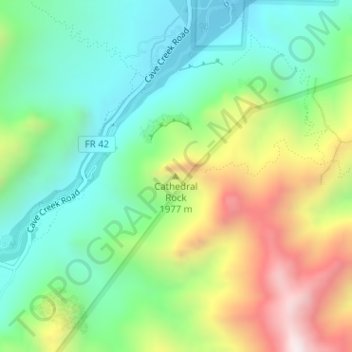
Name: Topografische Karte Cathedral Rock, Höhe, Relief.
Ort: Cathedral Rock, Cochise County, Arizona, United States (31.89024 -109.16034 31.89034 -109.16024)
Durchschnittliche Höhe: 1.774 m
Minimale Höhe: 1.489 m
Maximale Höhe: 2.302 m
Andere topografische Karten
Klicken Sie auf eine Karte, um ihre Topografie, ihre Höhe und ihr Relief anzuzeigen.
Chiricahua National Monument
United States > Arizona > Cochise County
Chiricahua National Monument, Cochise County, Arizona, United States
Durchschnittliche Höhe: 1.861 m
Willcox
United States > Arizona > Cochise County
Willcox, Cochise County, Arizona, 85643, United States
Durchschnittliche Höhe: 1.274 m
Bakerville
United States > Arizona > Cochise County > Bisbee > Warren
Bakerville, Warren, Bisbee, Cochise County, Arizona, 85603, United States
Durchschnittliche Höhe: 1.579 m
Douglas
United States > Arizona > Cochise County > Douglas
Douglas, Cochise County, Arizona, United States
Durchschnittliche Höhe: 1.265 m
Sierra Vista
United States > Arizona > Cochise County
Sierra Vista, Cochise County, Arizona, United States
Durchschnittliche Höhe: 1.507 m
Portal
United States > Arizona > Cochise County > Portal
Portal, Cochise County, Arizona, United States
Durchschnittliche Höhe: 1.523 m
Bisbee
United States > Arizona > Cochise County
Bisbee, Cochise County, Arizona, United States
Durchschnittliche Höhe: 1.676 m
Whetstone
United States > Arizona > Cochise County
Whetstone, Cochise County, Arizona, United States
Durchschnittliche Höhe: 1.324 m